IPhO 1998 · Theory problem 2
Water under an ice cap
An ice cap is a thick sheet of ice (up to a few km in thickness) resting on the ground below and extending horizontally over tens or hundreds of km. In this problem we consider the melting of ice and the behavior of water under a temperate ice cap, i.e. an ice cap at the melting point. We may assume that under such conditions the ice causes pressure variations as a viscous fluid, but deforms in a brittle fashion, principally by vertical movement. For the purposes of this problem the following information is given.
| Density of water: | \(\rho_w=1.000\cdot10^3\ \mathrm{kg/m^3}\) |
| Density of ice: | \(\rho_i=0.917\cdot10^3\ \mathrm{kg/m^3}\) |
| Specific heat of ice: | \(c_i=2.1\cdot10^3\ \mathrm{J/(kg\,^\circ C)}\) |
| Specific latent heat of ice: | \(L_i=3.4\cdot10^5\ \mathrm{J/kg}\) |
| Density of rock and magma: | \(\rho_r=2.9\cdot10^3\ \mathrm{kg/m^3}\) |
| Specific heat of rock and magma: | \(c_r=700\ \mathrm{J/(kg\,^\circ C)}\) |
| Specific latent heat of rock and magma: | \(L_r=4.2\cdot10^5\ \mathrm{J/kg}\) |
| Average outward heat flow through the surface of the earth: | \(J_Q=0.06\ \mathrm{W/m^2}\) |
| Melting point of ice: | \(T_0=0^\circ\mathrm C\), constant |
a) (0.5 points) Consider a thick ice cap at a location of average heat flow from the interior of the earth. Using the data from the table, calculate the thickness \(d\) of the ice layer melted every year and write your answer in the designated box on the answer sheet.
b) (3.5 points) Consider now the upper surface of an ice cap. The ground below the ice cap has a slope angle \(\alpha\). The upper surface of the cap slopes by an angle \(\beta\) as shown in Figure 2.1. The vertical thickness of the ice at \(x=0\) is \(h_0\). Hence the lower and upper surfaces of the ice cap can be described by the equations
\[ y_1=x\tan\alpha,\qquad y_2=h_0+x\tan\beta \tag{2.1} \]
Derive an expression for the pressure \(p\) at the bottom of the ice cap as a function of the horizontal coordinate \(x\) and write it on the answer sheet.
Formulate mathematically a condition between \(\beta\) and \(\alpha\), so that water in a layer between the ice cap and the ground will flow in neither direction. Show that the condition is of the form \(\tan\beta=s\tan\alpha\). Find the coefficient \(s\) and write the result in a symbolic form on the answer sheet.
The line \(y_1=0.8\,x\) in Figure 2.2 shows the surface of the earth below an ice cap. The vertical thickness \(h_0\) at \(x=0\) is 2 km. Assume that water at the bottom is in equilibrium. On a graph answer sheet draw the line \(y_1\) and add a line \(y_2\) showing the upper surface of the ice. Indicate on the figure which line is which.
\(^{6}\)Authors: Gudni Axelsson and Thorsteinn Vilhjálmsson
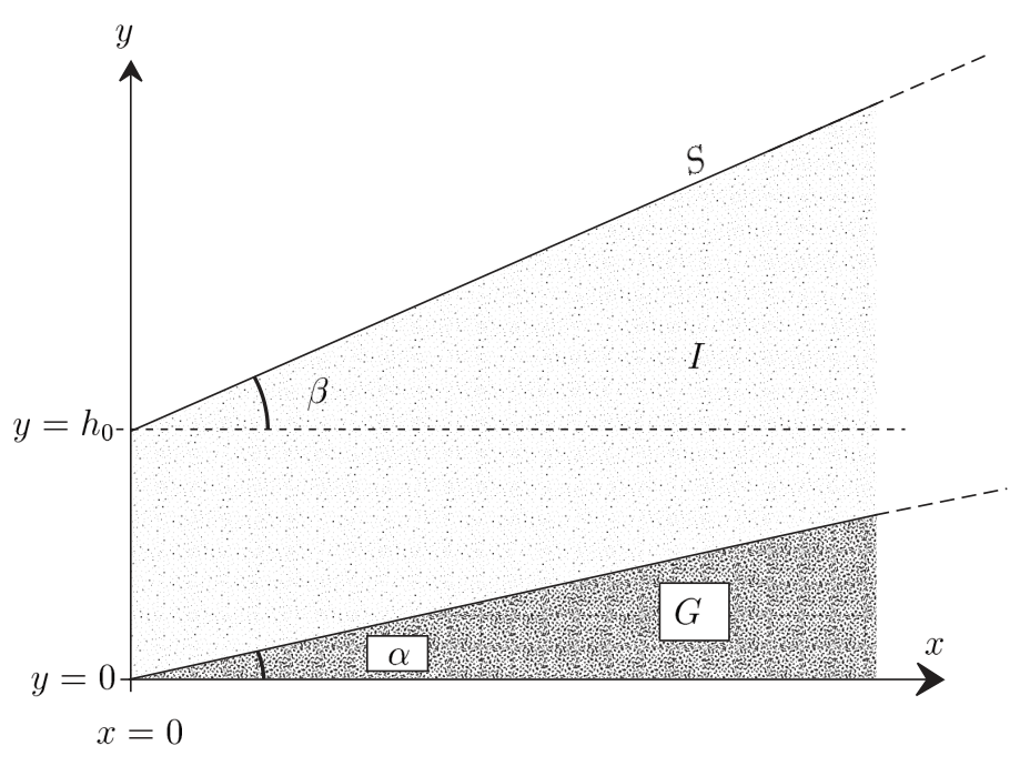
Figure 2.1: Cross section of an ice cap with a plane surface resting on an inclined plane ground. \(S\): surface, \(G\): ground, \(I\): ice cap.
c) (1 point) Within a large ice sheet on horizontal ground and originally of constant thickness \(D=2.0\) km, a conical body of water of height \(H=1.0\) km and radius \(r=1.0\) km is formed rather suddenly by melting of the ice (Figure 2.3). We assume that the remaining ice adapts to this by vertical motion only.
Show analytically on a blank answer sheet and pictorially on a graph answer sheet, the shape of the surface of the ice cap after the water cone has formed and hydrostatic equilibrium has been reached.
d) (5 points) In its annual expedition, an international group of scientists explores a temperate ice cap in Antarctica. The area is normally a wide plateau but this time they find a deep crater-like depression, formed like a top-down cone with a depth \(h\) of 100 m and a radius \(r\) of 500 m (Figure 2.4). The thickness of the ice in the area is 2000 m.
After a discussion the scientists conclude that most probably there was a minor volcanic eruption below the ice cap. A small amount of magma (molten rock) intruded at the bottom of the ice cap, solidified and cooled, melting a certain volume of ice. The scientists try as follows to estimate the volume of the intrusion and get an idea of what became of the melt water.
Assume that the ice only moved vertically. Also assume that the magma was completely molten and at \(1200^\circ\mathrm C\) at the start. For simplicity, assume further that the intrusion had the form of a cone with a circular base vertically below the conical depression in the surface. The time for the rising of the magma was short relative to the time for the exchange of heat in the process. The heat flow is assumed to have been primarily vertical such that the volume melted from the ice at any time is bounded by a conical surface centered above the center of the magma intrusion.
Given these assumptions the melting of the ice takes place in two steps. At first the water is not in pressure equilibrium at the surface of the magma and hence flows away. The water flowing away can be assumed to have a temperature of \(0^\circ\mathrm C\). Subsequently,
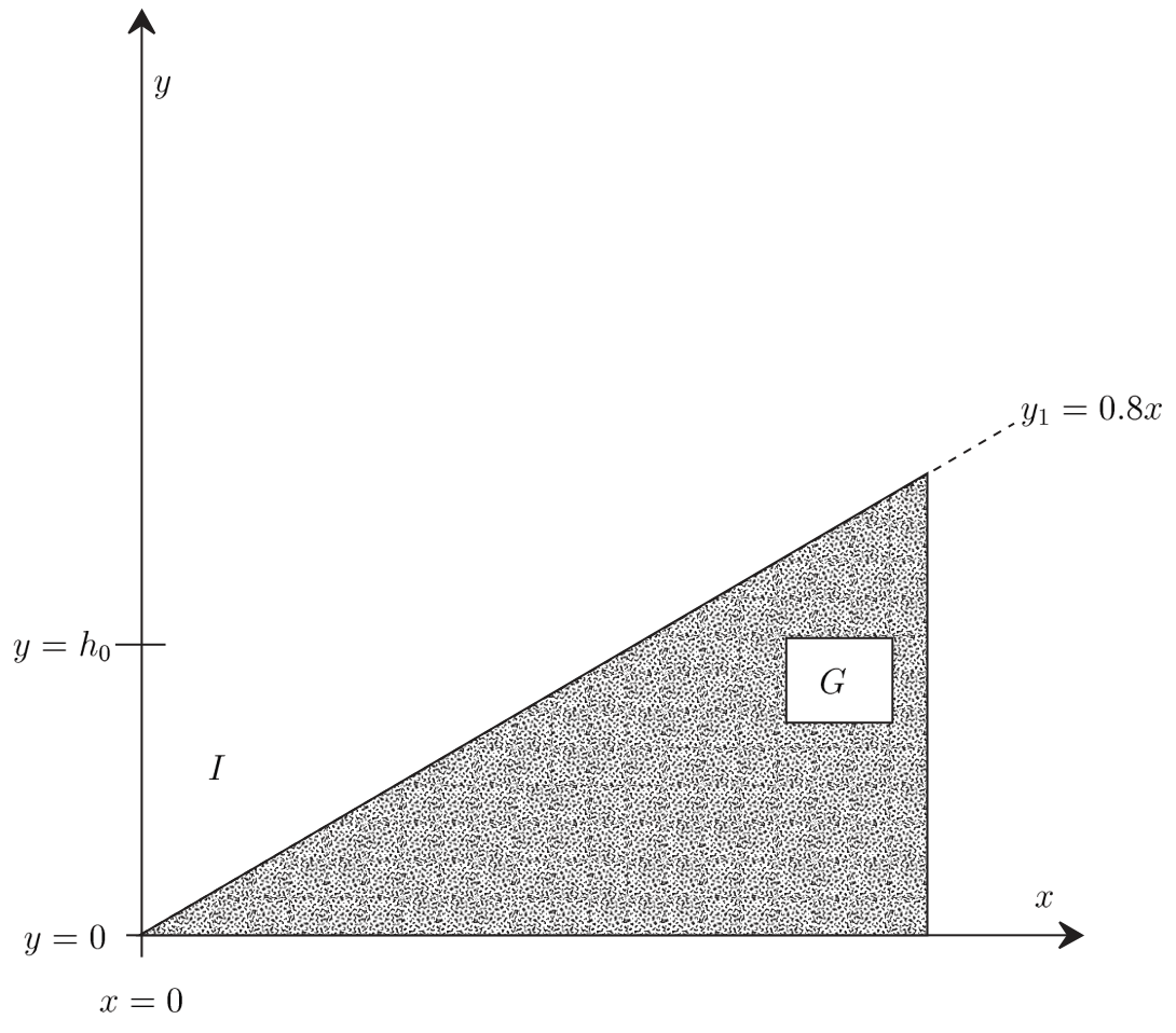
Figure 2.2: Cross section of a temperate ice cap resting on an inclined ground with water at the bottom in equilibrium. \(G\): ground, \(I\): ice cap.
hydrostatic equilibrium is reached and the water accumulates above the intrusion instead of flowing away.
When thermal equilibrium has been reached, you are asked to determine the following quantities. Write the answers on the answer sheet.
- The height \(H\) of the top of the water cone formed under the ice cap, relative to the original bottom of the ice cap.
- The height \(h_1\) of the intrusion.
- The total mass \(m_{tot}\) of the water produced and the mass \(m'\) of water that flows away.
Plot on a graph answer sheet, to scale, the shapes of the rock intrusion and of the body of water remaining. Use the coordinate system suggested in Figure 2.4.
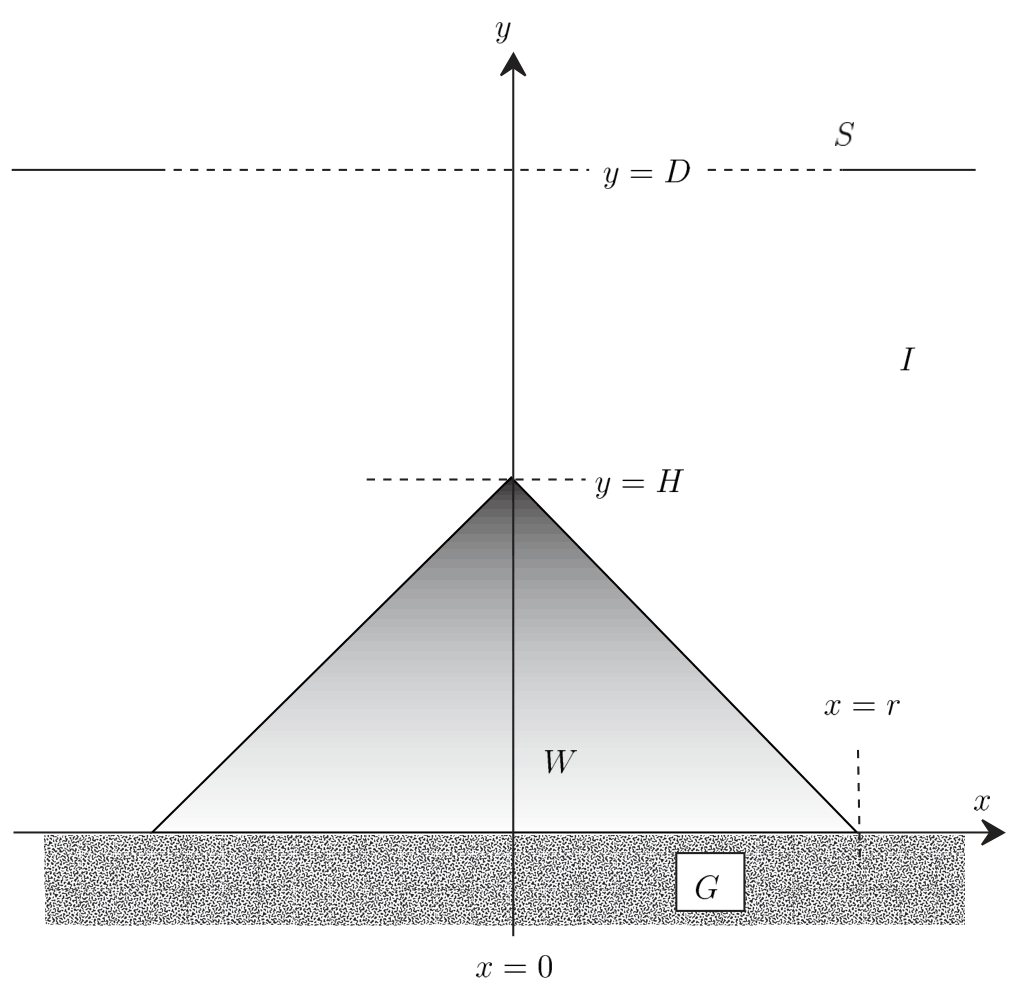
Figure 2.3: A vertical section through the mid-plane of a water cone inside an ice cap. \(S\): surface, \(W\): water, \(G\): ground, \(I\): ice cap.
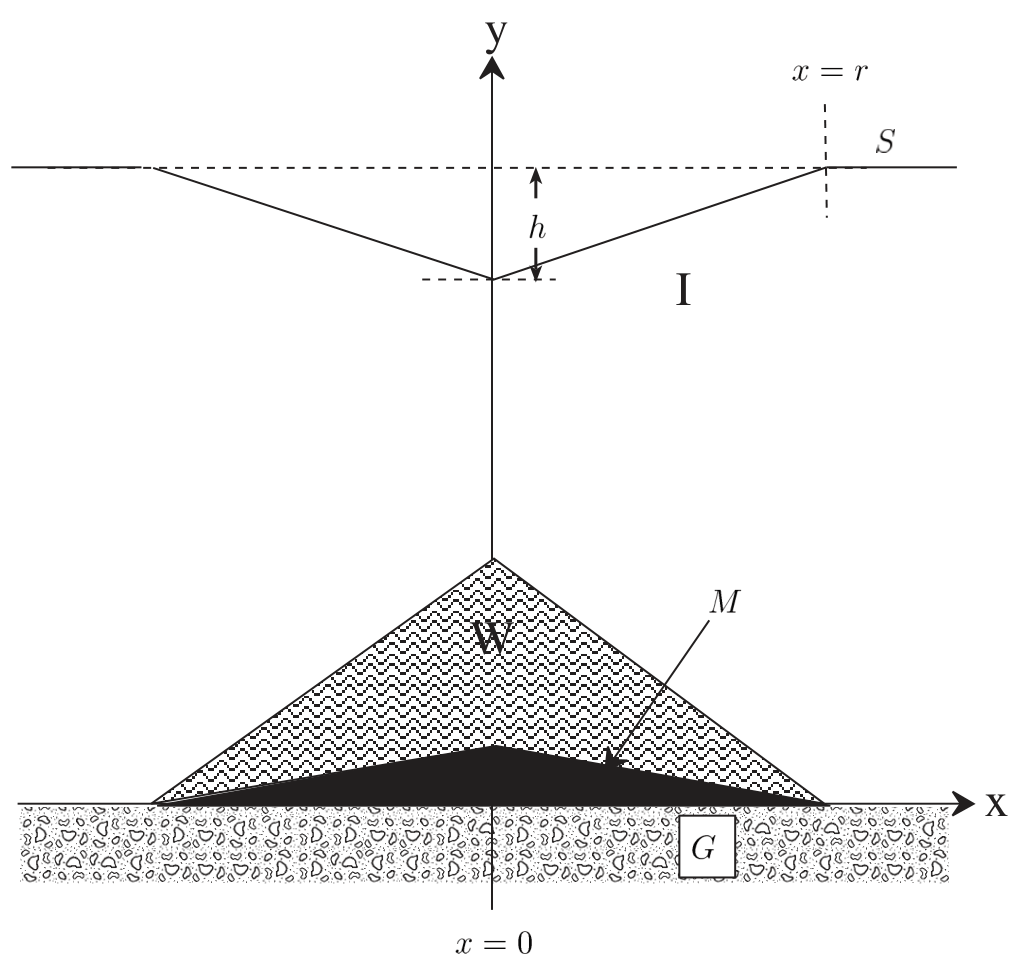
Figure 2.4: A vertical and central cross section of a conical depression in a temperate ice cap. \(S\): surface, \(G\): ground, \(I\): ice cap, \(M\): rock/magma intrusion, \(W\): water. Note that the figure is NOT drawn to scale.
Official English text of the problem.
Answers
-
a) The thickness melted each year is \[ \boxed{d\simeq6.1\times10^{-3}\ \mathrm m=6.1\ \mathrm{mm}.} \]
-
b) With uniform atmospheric pressure \(p_a\), \[ \boxed{p(x)-p_a=\rho_i g\left[h_0+x(\tan\beta-\tan\alpha)\right].} \] No flow requires \[ \boxed{\tan\beta=s\tan\alpha,\qquad s=\frac{\rho_i-\rho_w}{\rho_i}\simeq-0.09051.} \] For the requested graph, with both coordinates in kilometres, \[ \boxed{y_1=0.8x,\qquad y_2=2.000-0.07241x.} \] The lines intersect at approximately \((2.293,\ 1.834)\) km.
-
c) Let \(R\) be horizontal distance from the cone axis. The surface is \[ \boxed{ y_s(R)= \begin{cases} D-\dfrac{\rho_w-\rho_i}{\rho_i}H\left(1-\dfrac Rr\right), &0\le R\le r,\\[6pt] D,&R\ge r. \end{cases}} \] It is a conical depression of radius \(1.0\) km and depth approximately \(91\) m. Its central elevation is \(1.9095\) km above the bed.
-
d), 1. \[ \boxed{H=\frac{\rho_i h}{\rho_w-\rho_i} \simeq1.10\times10^3\ \mathrm m.} \]
-
d), 2. \[ \boxed{h_1\simeq103\ \mathrm m.} \] The intrusion volume is approximately \(2.7\times10^7\ \mathrm{m^3}\).
-
d), 3. \[ \boxed{m_{tot}\simeq2.9\times10^{11}\ \mathrm{kg},\qquad m'\simeq2.7\times10^{10}\ \mathrm{kg}.} \] About \(9.3\%\) of the meltwater escapes. For the plot, define \(f(x)=1-|x|/(500\ \mathrm m)\) for \(|x|\le500\ \mathrm m\). The rock surface and water–ice boundary are \[ \boxed{y_M=(102.8\ \mathrm m)f(x),\qquad y_W=(1104.8\ \mathrm m)f(x).} \] Water occupies the region between these two surfaces.
Solution
a) Annual melting
The ice is already at its melting point, so the supplied geothermal heat goes into latent heat. For a horizontal area \(A\), conservation of energy over one year gives
\[ J_QAt=\rho_i AdL_i. \]
Thus
\[ d=\frac{J_Qt}{\rho_iL_i}. \]
Taking one year as \(365\times24\times3600=3.1536\times10^7\) s,
\[ d= \frac{0.06(3.1536\times10^7)} {(917)(3.4\times10^5)} =6.069\times10^{-3}\ \mathrm m. \]
Therefore approximately \(6.1\) mm of ice melts each year. The specific heat of ice is unnecessary because no initial warming is required.
b) Pressure and the condition for no water flow
The vertical ice thickness is
\[ h_i(x)=y_2-y_1 =h_0+x(\tan\beta-\tan\alpha). \]
Using the stated model, the basal pressure equals atmospheric pressure plus the weight of the overlying ice per unit horizontal area:
\[ \boxed{p(x)=p_a+\rho_i g \left[h_0+x(\tan\beta-\tan\alpha)\right].} \]
If pressure is measured relative to the atmosphere, the \(p_a\) term is omitted.
For water at rest, hydrostatic equilibrium requires
\[ p+\rho_wgy=\text{constant}. \]
Along the thin water layer, \(y=y_1(x)\), so the no-flow condition is
\[ \frac{dp}{dx}+\rho_wg\frac{dy_1}{dx}=0. \]
Substituting the pressure and ground slope,
\[ \rho_i g(\tan\beta-\tan\alpha) +\rho_wg\tan\alpha=0. \]
Consequently,
\[ \boxed{\tan\beta =\frac{\rho_i-\rho_w}{\rho_i}\tan\alpha}, \qquad \boxed{s=\frac{\rho_i-\rho_w}{\rho_i}}. \]
Numerically,
\[ s=\frac{917-1000}{917}=-0.0905125. \]
The negative sign means that the ice surface must slope downward in the direction in which the ground rises.
For \(y_1=0.8x\) and \(h_0=2\) km,
\[ \tan\beta=(-0.0905125)(0.8)=-0.0724100, \]
giving, with \(x\) and \(y\) in kilometres,
\[ \boxed{y_1=0.8x,\qquad y_2=2.000-0.0724100x.} \]
Draw the ground as a straight rising line through the origin and the ice surface as a gently descending line through \((0,2)\). Useful plotting coordinates are:
| \(x\) (km) | Ground \(y_1\) (km) | Ice surface \(y_2\) (km) |
|---|---|---|
| 0 | 0 | 2.000 |
| 1.000 | 0.800 | 1.928 |
| 2.000 | 1.600 | 1.855 |
| 2.2925 | 1.834 | 1.834 |
For \(x\ge0\), the ice lies between these lines up to their intersection.
c) Surface above a conical water body
Let \(z(R)\) denote the elevation of the ice–water boundary above the horizontal bed:
\[ z(R)=H\left(1-\frac Rr\right), \qquad 0\le R\le r. \]
At the rim, the water thickness tends to zero and the ice retains its original thickness \(D\). Hence the water pressure at bed level is
\[ p_b=p_a+\rho_i gD. \]
Hydrostatic equilibrium gives the pressure at elevation \(z\):
\[ p_w(z)=p_a+\rho_i gD-\rho_wgz. \]
The ice column above that point has thickness \(y_s-z\), and therefore exerts pressure
\[ p_i=p_a+\rho_i g(y_s-z). \]
Equating the pressures at the ice–water boundary,
\[ \rho_i(y_s-z)=\rho_iD-\rho_wz. \]
Thus
\[ y_s=D-\frac{\rho_w-\rho_i}{\rho_i}z. \]
Substitution of the conical boundary gives
\[ \boxed{ y_s(R)=D-\frac{\rho_w-\rho_i}{\rho_i} H\left(1-\frac Rr\right), \qquad 0\le R\le r.} \]
Outside the footprint, \(y_s=D\). The depression depth is
\[ \delta= \frac{\rho_w-\rho_i}{\rho_i}H =\frac{83}{917}(1000\ \mathrm m) =90.51\ \mathrm m. \]
Therefore the surface is an inverted cone of radius \(1.0\) km, meeting the surrounding horizontal surface continuously. Its lowest point is
\[ y_s(0)=2000-90.51=1909.49\ \mathrm m. \]
For a central vertical section, set \(R=|x|\). With coordinates in kilometres, join
\[ (-1.000,\ 2.000),\qquad (0,\ 1.90949),\qquad (1.000,\ 2.000) \]
by straight segments, and continue horizontally at \(y=2.000\) km on both sides. Rotating this profile about the vertical axis gives the surface depression.
d) Volcanic intrusion
Let
\[ f(R)=1-\frac Rr,\qquad 0\le R\le r, \]
where \(r=500\) m. The final surface, water–ice boundary, and rock surface have the forms
\[ y_s=D-hf(R),\qquad y_W=Hf(R),\qquad y_M=h_1f(R). \]
Here \(D=2000\) m and \(h=100\) m.
1. Height of the top of the water cone
The hydrostatic relation derived in part c applies again:
\[ D-y_s=\frac{\rho_w-\rho_i}{\rho_i}y_W. \]
At the centre,
\[ h=\frac{\rho_w-\rho_i}{\rho_i}H. \]
Hence
\[ \boxed{H=\frac{\rho_i h}{\rho_w-\rho_i} =\frac{917(100)}{83} =1104.82\ \mathrm m.} \]
This height is measured from the original bed. The actual central water depth will be \(H-h_1\).
2. Height of the intrusion
First determine how much ice has melted. The final ice thickness in a vertical column is
\[ y_s-y_W=D-(h+H)f(R). \]
Since ice moves only vertically, each column loses an ice thickness
\[ (h+H)f(R). \]
The initial lifting by the magma does not change the amount of ice in a column. Thus the total melted ice volume is
\[ V_{\mathrm{melt}} =\int_0^r (h+H)\left(1-\frac Rr\right)2\pi R\,dR =\frac{\pi r^2}{3}(h+H). \]
Write
\[ C=\frac{\pi r^2}{3}. \]
Then
\[ m_{tot}=\rho_i C(h+H), \qquad V_M=Ch_1, \qquad m_M=\rho_rCh_1. \]
At final thermal equilibrium, the rock and the ice–water mixture are at \(0^\circ\mathrm C\). Each kilogram of magma releases
\[ q_M=L_r+c_r(1200^\circ\mathrm C-T_0) =4.2\times10^5+700(1200) =1.26\times10^6\ \mathrm{J/kg}. \]
This includes both solidification and cooling. Neglecting heat losses and small mechanical-energy changes, conservation of energy gives
\[ \rho_rCh_1q_M=\rho_i C(h+H)L_i. \]
Therefore
\[ h_1= \frac{\rho_i(h+H)L_i} {\rho_r[L_r+c_r(1200^\circ\mathrm C-T_0)]}. \]
The hydrostatic relation also implies
\[ \rho_i(h+H)=\rho_wH, \]
so equivalently,
\[ h_1= \frac{\rho_wHL_i} {\rho_r[L_r+c_r(1200^\circ\mathrm C-T_0)]}. \]
Numerically,
\[ \boxed{ h_1= \frac{1000(1104.819)(3.4\times10^5)} {2900(1.26\times10^6)} =102.80\ \mathrm m \simeq103\ \mathrm m.} \]
The intrusion volume is consequently
\[ V_M=\frac{\pi(500)^2}{3}(102.802) =2.691\times10^7\ \mathrm{m^3}. \]
3. Total water production and water escaping
From the melted ice volume,
\[ m_{tot} =\rho_iC(h+H) =\rho_wCH. \]
Thus
\[ \boxed{ m_{tot} =1000\frac{\pi(500)^2}{3}(1104.819) =2.8924\times10^{11}\ \mathrm{kg} \simeq2.9\times10^{11}\ \mathrm{kg}.} \]
The remaining water occupies the space between the water–ice cone and the rock cone. Its volume is
\[ V_{\mathrm{remaining}}=C(H-h_1), \]
and its mass is
\[ m_{\mathrm{remaining}} =\rho_wC(H-h_1) =2.6233\times10^{11}\ \mathrm{kg}. \]
Mass conservation therefore gives
\[ \begin{aligned} m' &=m_{tot}-m_{\mathrm{remaining}}\\ &=\rho_wCH-\rho_wC(H-h_1)\\ &=\rho_wCh_1. \end{aligned} \]
Hence
\[ \boxed{ m'=1000\frac{\pi(500)^2}{3}(102.802) =2.6914\times10^{10}\ \mathrm{kg} \simeq2.7\times10^{10}\ \mathrm{kg}.} \]
The escaped water volume equals the intrusion volume:
\[ \boxed{\frac{m'}{\rho_w}=V_M.} \]
This also explains the two stages. Initially the magma lifts the ice without reducing its thickness, so water on the elevated rock surface has excess hydraulic pressure and drains away. At the end of this drainage stage, the ice–water boundary is approximately the rock surface \(h_1f(R)\). Hydrostatic equilibrium then requires an ice thickness
\[ D-\frac{\rho_w}{\rho_i}h_1f(R). \]
The ice melted by that stage has mass \(\rho_wCh_1\), exactly the escaped mass found above. Further melting produces the retained water body.
Description of the plot
For a central vertical section, use \(R=|x|\). Within \(|x|\le500\) m,
\[ \begin{aligned} y_M(x)&=102.802\left(1-\frac{|x|}{500}\right)\ \mathrm m,\\ y_W(x)&=1104.819\left(1-\frac{|x|}{500}\right)\ \mathrm m,\\ y_s(x)&=2000-100\left(1-\frac{|x|}{500}\right)\ \mathrm m, \end{aligned} \]
where \(x\) is numerically expressed in metres.
Use the following coordinates and join adjacent points by straight lines:
| \(x\) (m) | Rock surface \(y_M\) (m) | Water–ice boundary \(y_W\) (m) | Ice surface \(y_s\) (m) |
|---|---|---|---|
| \(-500\) | 0 | 0 | 2000 |
| \(-250\) | 51.4 | 552.4 | 1950 |
| \(0\) | 102.8 | 1104.8 | 1900 |
| \(250\) | 51.4 | 552.4 | 1950 |
| \(500\) | 0 | 0 | 2000 |
Draw the original bed along \(y=0\), shade the intrusion between the bed and \(y_M\), and shade the water between \(y_M\) and \(y_W\). The ice lies between \(y_W\) and \(y_s\). Outside the footprint, the bed remains at \(y=0\) and the ice surface at \(y=2000\) m.
Using equal length scales on both axes, the intrusion is only about \(103\) m high, while the water boundary reaches about \(1105\) m. The central water depth is
\[ H-h_1\simeq1002\ \mathrm m, \]
and the remaining ice directly above it is about \(795\) m thick.
The solution was checked against the official solution.
IPhO 1998 · Theorieaufgabe 2
Wasser unter einer Eiskappe
Eine Eiskappe ist eine mächtige Eisschicht (bis zu einigen km dick), die auf dem darunterliegenden Boden aufliegt und sich horizontal über einige zehn oder hundert km erstreckt. In dieser Aufgabe betrachten wir das Schmelzen von Eis und das Verhalten von Wasser unter einer temperierten Eiskappe, d. h. einer Eiskappe am Schmelzpunkt. Wir dürfen annehmen, dass das Eis unter diesen Bedingungen Druckänderungen wie eine viskose Flüssigkeit hervorruft, sich jedoch spröde verformt, hauptsächlich durch vertikale Bewegung. Für diese Aufgabe sind die folgenden Angaben gegeben.
| Dichte von Wasser: | \(\rho_w=1.000\cdot10^3\ \mathrm{kg/m^3}\) |
| Dichte von Eis: | \(\rho_i=0.917\cdot10^3\ \mathrm{kg/m^3}\) |
| Spezifische Wärmekapazität von Eis: | \(c_i=2.1\cdot10^3\ \mathrm{J/(kg\,^\circ C)}\) |
| Spezifische Schmelzwärme von Eis: | \(L_i=3.4\cdot10^5\ \mathrm{J/kg}\) |
| Dichte von Gestein und Magma: | \(\rho_r=2.9\cdot10^3\ \mathrm{kg/m^3}\) |
| Spezifische Wärmekapazität von Gestein und Magma: | \(c_r=700\ \mathrm{J/(kg\,^\circ C)}\) |
| Spezifische Schmelzwärme von Gestein und Magma: | \(L_r=4.2\cdot10^5\ \mathrm{J/kg}\) |
| Mittlere nach außen gerichtete Wärmestromdichte durch die Erdoberfläche: | \(J_Q=0.06\ \mathrm{W/m^2}\) |
| Schmelzpunkt von Eis: | \(T_0=0^\circ\mathrm C\), konstant |
a) (0.5 Punkte) Betrachten Sie eine mächtige Eiskappe an einem Ort mit durchschnittlichem Wärmestrom aus dem Erdinneren. Berechnen Sie anhand der Daten in der Tabelle die Dicke \(d\) der Eisschicht, die jedes Jahr schmilzt, und tragen Sie Ihre Antwort in das dafür vorgesehene Feld auf dem Antwortblatt ein.
b) (3.5 Punkte) Betrachten Sie nun die obere Oberfläche einer Eiskappe. Der Boden unter der Eiskappe hat einen Neigungswinkel \(\alpha\). Die obere Oberfläche der Eiskappe ist um den Winkel \(\beta\) geneigt, wie in Abbildung 2.1 dargestellt. Die vertikale Eisdicke bei \(x=0\) beträgt \(h_0\). Somit lassen sich die untere und die obere Oberfläche der Eiskappe durch die folgenden Gleichungen beschreiben:
\[ y_1=x\tan\alpha,\qquad y_2=h_0+x\tan\beta \tag{2.1} \]
Leiten Sie einen Ausdruck für den Druck \(p\) an der Unterseite der Eiskappe als Funktion der horizontalen Koordinate \(x\) her und tragen Sie ihn auf dem Antwortblatt ein.
Formulieren Sie mathematisch eine Bedingung zwischen \(\beta\) und \(\alpha\), damit Wasser in einer Schicht zwischen der Eiskappe und dem Boden in keine der beiden Richtungen fließt. Zeigen Sie, dass die Bedingung die Form \(\tan\beta=s\tan\alpha\) hat. Bestimmen Sie den Koeffizienten \(s\) und tragen Sie das Ergebnis in symbolischer Form auf dem Antwortblatt ein.
Die Gerade \(y_1=0.8\,x\) in Abbildung 2.2 zeigt die Erdoberfläche unter einer Eiskappe. Die vertikale Dicke \(h_0\) bei \(x=0\) beträgt 2 km. Nehmen Sie an, dass sich das Wasser am Boden im Gleichgewicht befindet. Zeichnen Sie auf einem Diagramm-Antwortblatt die Gerade \(y_1\) und ergänzen Sie eine Gerade \(y_2\), die die obere Oberfläche des Eises darstellt. Kennzeichnen Sie in der Abbildung, welche Gerade welche ist.
\(^{6}\)Autoren: Gudni Axelsson und Thorsteinn Vilhjálmsson
Abbildung 2.1: Querschnitt einer Eiskappe mit ebener Oberfläche, die auf einem geneigten ebenen Boden aufliegt. \(S\): Oberfläche, \(G\): Boden, \(I\): Eiskappe.
c) (1 Punkt) Innerhalb einer großen Eisschicht auf horizontalem Boden mit ursprünglich konstanter Dicke \(D=2.0\) km entsteht durch Schmelzen des Eises relativ plötzlich ein kegelförmiger Wasserkörper mit der Höhe \(H=1.0\) km und dem Radius \(r=1.0\) km (Abbildung 2.3). Wir nehmen an, dass sich das verbleibende Eis ausschließlich durch vertikale Bewegung daran anpasst.
Zeigen Sie analytisch auf einem leeren Antwortblatt und zeichnerisch auf einem Diagramm-Antwortblatt die Form der Oberfläche der Eiskappe, nachdem sich der Wasserkegel gebildet hat und das hydrostatische Gleichgewicht erreicht ist.
d) (5 Punkte) Auf ihrer jährlichen Expedition erkundet eine internationale Gruppe von Wissenschaftlern eine temperierte Eiskappe in der Antarktis. Das Gebiet ist normalerweise ein weites Plateau, doch diesmal finden sie eine tiefe kraterartige Senke in Form eines mit der Spitze nach unten gerichteten Kegels mit einer Tiefe \(h\) von 100 m und einem Radius \(r\) von 500 m (Abbildung 2.4). Die Eisdicke in diesem Gebiet beträgt 2000 m.
Nach einer Diskussion kommen die Wissenschaftler zu dem Schluss, dass es höchstwahrscheinlich einen kleineren Vulkanausbruch unter der Eiskappe gegeben hat. Eine kleine Menge Magma (geschmolzenes Gestein) drang an der Unterseite der Eiskappe ein, erstarrte und kühlte ab, wobei ein bestimmtes Eisvolumen schmolz. Die Wissenschaftler versuchen im Folgenden, das Volumen der Intrusion abzuschätzen und sich ein Bild davon zu machen, was aus dem Schmelzwasser geworden ist.
Nehmen Sie an, dass sich das Eis nur vertikal bewegte. Nehmen Sie außerdem an, dass das Magma zu Beginn vollständig geschmolzen war und eine Temperatur von \(1200^\circ\mathrm C\) hatte. Nehmen Sie zur Vereinfachung ferner an, dass die Intrusion die Form eines Kegels mit kreisförmiger Grundfläche senkrecht unter der kegelförmigen Senke an der Oberfläche hatte. Die Aufstiegszeit des Magmas war kurz im Vergleich zur Dauer des Wärmeaustauschs während dieses Vorgangs. Es wird angenommen, dass der Wärmestrom hauptsächlich vertikal gerichtet war, sodass das aus dem Eis geschmolzene Volumen zu jedem Zeitpunkt durch eine Kegelfläche begrenzt ist, deren Mittelpunkt über dem Mittelpunkt der Magmaintrusion liegt.
Unter diesen Annahmen erfolgt das Schmelzen des Eises in zwei Schritten. Zunächst befindet sich das Wasser an der Oberfläche des Magmas nicht im Druckgleichgewicht und fließt daher ab. Für das abfließende Wasser kann eine Temperatur von \(0^\circ\mathrm C\) angenommen werden. Anschließend
Abbildung 2.2: Querschnitt einer temperierten Eiskappe auf geneigtem Boden mit Wasser an der Unterseite im Gleichgewicht. \(G\): Boden, \(I\): Eiskappe.
wird das hydrostatische Gleichgewicht erreicht, und das Wasser sammelt sich über der Intrusion, anstatt abzufließen.
Bestimmen Sie die folgenden Größen für den Zustand, in dem das thermische Gleichgewicht erreicht ist. Tragen Sie die Antworten auf dem Antwortblatt ein.
- Die Höhe \(H\) der Spitze des unter der Eiskappe entstandenen Wasserkegels, bezogen auf die ursprüngliche Unterseite der Eiskappe.
- Die Höhe \(h_1\) der Intrusion.
- Die Gesamtmasse \(m_{tot}\) des entstandenen Wassers und die Masse \(m'\) des abfließenden Wassers.
Zeichnen Sie auf einem Diagramm-Antwortblatt maßstabsgetreu die Formen der Gesteinsintrusion und des verbleibenden Wasserkörpers. Verwenden Sie das in Abbildung 2.4 vorgeschlagene Koordinatensystem.
Abbildung 2.3: Ein vertikaler Schnitt durch die Mittelebene eines Wasserkegels innerhalb einer Eiskappe. \(S\): Oberfläche, \(W\): Wasser, \(G\): Boden, \(I\): Eiskappe.
Abbildung 2.4: Ein vertikaler Schnitt durch die Mitte einer kegelförmigen Senke in einer temperierten Eiskappe. \(S\): Oberfläche, \(G\): Boden, \(I\): Eiskappe, \(M\): Gesteins-/Magmaintrusion, \(W\): Wasser. Beachten Sie, dass die Abbildung NICHT maßstabsgetreu gezeichnet ist.
Aufgabentext aus dem offiziellen englischen Text übersetzt.
Antworten
-
a) Die jährlich abgeschmolzene Dicke beträgt \[ \boxed{d\simeq6.1\times10^{-3}\ \mathrm m=6.1\ \mathrm{mm}.} \]
-
b) Bei gleichförmigem Atmosphärendruck \(p_a\) gilt \[ \boxed{p(x)-p_a=\rho_i g\left[h_0+x(\tan\beta-\tan\alpha)\right].} \] Damit kein Wasser fließt, muss gelten \[ \boxed{\tan\beta=s\tan\alpha,\qquad s=\frac{\rho_i-\rho_w}{\rho_i}\simeq-0.09051.} \] Für das geforderte Diagramm gilt mit beiden Koordinaten in Kilometern \[ \boxed{y_1=0.8x,\qquad y_2=2.000-0.07241x.} \] Die Geraden schneiden sich ungefähr bei \((2.293,\ 1.834)\) km.
-
c) Sei \(R\) der horizontale Abstand von der Kegelachse. Die Oberfläche ist \[ \boxed{ y_s(R)= \begin{cases} D-\dfrac{\rho_w-\rho_i}{\rho_i}H\left(1-\dfrac Rr\right), &0\le R\le r,\\[6pt] D,&R\ge r. \end{cases}} \] Es handelt sich um eine kegelförmige Senke mit einem Radius von \(1.0\) km und einer Tiefe von ungefähr \(91\) m. Ihre Höhe im Zentrum beträgt \(1.9095\) km über dem Untergrund.
-
d), 1. \[ \boxed{H=\frac{\rho_i h}{\rho_w-\rho_i} \simeq1.10\times10^3\ \mathrm m.} \]
-
d), 2. \[ \boxed{h_1\simeq103\ \mathrm m.} \] Das Volumen der Intrusion beträgt ungefähr \(2.7\times10^7\ \mathrm{m^3}\).
-
d), 3. \[ \boxed{m_{tot}\simeq2.9\times10^{11}\ \mathrm{kg},\qquad m'\simeq2.7\times10^{10}\ \mathrm{kg}.} \] Etwa \(9.3\%\) des Schmelzwassers fließen ab. Definieren Sie für die Zeichnung \(f(x)=1-|x|/(500\ \mathrm m)\) für \(|x|\le500\ \mathrm m\). Die Gesteinsoberfläche und die Wasser-Eis-Grenzfläche sind \[ \boxed{y_M=(102.8\ \mathrm m)f(x),\qquad y_W=(1104.8\ \mathrm m)f(x).} \] Das Wasser füllt den Bereich zwischen diesen beiden Flächen aus.
Lösung
a) Jährliches Schmelzen
Das Eis befindet sich bereits am Schmelzpunkt, sodass die zugeführte Erdwärme als Schmelzwärme aufgenommen wird. Für eine horizontale Fläche \(A\) ergibt die Energieerhaltung über ein Jahr
\[ J_QAt=\rho_i AdL_i. \]
Somit gilt
\[ d=\frac{J_Qt}{\rho_iL_i}. \]
Setzt man ein Jahr gleich \(365\times24\times3600=3.1536\times10^7\) s, erhält man
\[ d= \frac{0.06(3.1536\times10^7)} {(917)(3.4\times10^5)} =6.069\times10^{-3}\ \mathrm m. \]
Damit schmelzen jedes Jahr ungefähr \(6.1\) mm Eis. Die spezifische Wärmekapazität des Eises wird nicht benötigt, da keine anfängliche Erwärmung erforderlich ist.
b) Druck und Bedingung dafür, dass kein Wasser fließt
Die vertikale Eisdicke beträgt
\[ h_i(x)=y_2-y_1 =h_0+x(\tan\beta-\tan\alpha). \]
Im angegebenen Modell ist der Druck an der Unterseite gleich dem Atmosphärendruck zuzüglich der Gewichtskraft des darüberliegenden Eises pro horizontaler Flächeneinheit:
\[ \boxed{p(x)=p_a+\rho_i g \left[h_0+x(\tan\beta-\tan\alpha)\right].} \]
Wird der Druck relativ zum Atmosphärendruck gemessen, entfällt der Term \(p_a\).
Für ruhendes Wasser erfordert das hydrostatische Gleichgewicht
\[ p+\rho_wgy=\text{konstant}. \]
Entlang der dünnen Wasserschicht gilt \(y=y_1(x)\), sodass die Bedingung für das Ausbleiben einer Strömung lautet
\[ \frac{dp}{dx}+\rho_wg\frac{dy_1}{dx}=0. \]
Einsetzen des Drucks und der Bodenneigung ergibt
\[ \rho_i g(\tan\beta-\tan\alpha) +\rho_wg\tan\alpha=0. \]
Folglich gilt
\[ \boxed{\tan\beta =\frac{\rho_i-\rho_w}{\rho_i}\tan\alpha}, \qquad \boxed{s=\frac{\rho_i-\rho_w}{\rho_i}}. \]
Numerisch ergibt sich
\[ s=\frac{917-1000}{917}=-0.0905125. \]
Das negative Vorzeichen bedeutet, dass die Eisoberfläche in der Richtung abfallen muss, in der der Boden ansteigt.
Für \(y_1=0.8x\) und \(h_0=2\) km gilt
\[ \tan\beta=(-0.0905125)(0.8)=-0.0724100, \]
woraus sich mit \(x\) und \(y\) in Kilometern ergibt
\[ \boxed{y_1=0.8x,\qquad y_2=2.000-0.0724100x.} \]
Zeichnen Sie den Boden als ansteigende Gerade durch den Ursprung und die Eisoberfläche als leicht abfallende Gerade durch \((0,2)\). Hilfreiche Koordinaten für die Zeichnung sind:
| \(x\) (km) | Boden \(y_1\) (km) | Eisoberfläche \(y_2\) (km) |
|---|---|---|
| 0 | 0 | 2.000 |
| 1.000 | 0.800 | 1.928 |
| 2.000 | 1.600 | 1.855 |
| 2.2925 | 1.834 | 1.834 |
Für \(x\ge0\) liegt das Eis bis zum Schnittpunkt zwischen diesen Geraden.
c) Oberfläche über einem kegelförmigen Wasserkörper
Sei \(z(R)\) die Höhe der Eis-Wasser-Grenzfläche über dem horizontalen Untergrund:
\[ z(R)=H\left(1-\frac Rr\right), \qquad 0\le R\le r. \]
Am Rand geht die Wasserdicke gegen null, und das Eis behält seine ursprüngliche Dicke \(D\). Daher beträgt der Wasserdruck auf Höhe des Untergrunds
\[ p_b=p_a+\rho_i gD. \]
Aus dem hydrostatischen Gleichgewicht ergibt sich der Druck in der Höhe \(z\):
\[ p_w(z)=p_a+\rho_i gD-\rho_wgz. \]
Die Eissäule über diesem Punkt hat die Dicke \(y_s-z\) und übt daher folgenden Druck aus:
\[ p_i=p_a+\rho_i g(y_s-z). \]
Gleichsetzen der Drücke an der Eis-Wasser-Grenzfläche ergibt
\[ \rho_i(y_s-z)=\rho_iD-\rho_wz. \]
Somit gilt
\[ y_s=D-\frac{\rho_w-\rho_i}{\rho_i}z. \]
Einsetzen der kegelförmigen Grenzfläche ergibt
\[ \boxed{ y_s(R)=D-\frac{\rho_w-\rho_i}{\rho_i} H\left(1-\frac Rr\right), \qquad 0\le R\le r.} \]
Außerhalb der Grundfläche gilt \(y_s=D\). Die Tiefe der Senke beträgt
\[ \delta= \frac{\rho_w-\rho_i}{\rho_i}H =\frac{83}{917}(1000\ \mathrm m) =90.51\ \mathrm m. \]
Die Oberfläche bildet somit einen umgekehrten Kegel mit dem Radius \(1.0\) km, der stetig in die umgebende horizontale Oberfläche übergeht. Sein tiefster Punkt liegt bei
\[ y_s(0)=2000-90.51=1909.49\ \mathrm m. \]
Für einen vertikalen Schnitt durch die Mitte setzen Sie \(R=|x|\). Verbinden Sie bei Koordinaten in Kilometern die Punkte
\[ (-1.000,\ 2.000),\qquad (0,\ 1.90949),\qquad (1.000,\ 2.000) \]
durch gerade Strecken und setzen Sie das Profil auf beiden Seiten horizontal bei \(y=2.000\) km fort. Durch Rotation dieses Profils um die vertikale Achse erhält man die Oberflächensenke.
d) Vulkanische Intrusion
Es sei
\[ f(R)=1-\frac Rr,\qquad 0\le R\le r, \]
wobei \(r=500\) m ist. Die endgültige Oberfläche, die Wasser-Eis-Grenzfläche und die Gesteinsoberfläche haben die Formen
\[ y_s=D-hf(R),\qquad y_W=Hf(R),\qquad y_M=h_1f(R). \]
Hierbei sind \(D=2000\) m und \(h=100\) m.
1. Höhe der Spitze des Wasserkegels
Die in Teil c hergeleitete hydrostatische Beziehung gilt erneut:
\[ D-y_s=\frac{\rho_w-\rho_i}{\rho_i}y_W. \]
Im Zentrum gilt
\[ h=\frac{\rho_w-\rho_i}{\rho_i}H. \]
Daher folgt
\[ \boxed{H=\frac{\rho_i h}{\rho_w-\rho_i} =\frac{917(100)}{83} =1104.82\ \mathrm m.} \]
Diese Höhe wird vom ursprünglichen Untergrund aus gemessen. Die tatsächliche Wassertiefe im Zentrum wird \(H-h_1\) betragen.
2. Höhe der Intrusion
Bestimmen Sie zunächst, wie viel Eis geschmolzen ist. Die endgültige Eisdicke in einer vertikalen Säule beträgt
\[ y_s-y_W=D-(h+H)f(R). \]
Da sich das Eis nur vertikal bewegt, verliert jede Säule eine Eisdicke von
\[ (h+H)f(R). \]
Das anfängliche Anheben durch das Magma ändert die Eismenge in einer Säule nicht. Daher beträgt das gesamte geschmolzene Eisvolumen
\[ V_{\mathrm{melt}} =\int_0^r (h+H)\left(1-\frac Rr\right)2\pi R\,dR =\frac{\pi r^2}{3}(h+H). \]
Schreiben wir
\[ C=\frac{\pi r^2}{3}. \]
Dann gilt
\[ m_{tot}=\rho_i C(h+H), \qquad V_M=Ch_1, \qquad m_M=\rho_rCh_1. \]
Im endgültigen thermischen Gleichgewicht haben das Gestein und das Eis-Wasser-Gemisch eine Temperatur von \(0^\circ\mathrm C\). Jedes Kilogramm Magma setzt folgende Wärme frei:
\[ q_M=L_r+c_r(1200^\circ\mathrm C-T_0) =4.2\times10^5+700(1200) =1.26\times10^6\ \mathrm{J/kg}. \]
Darin sind sowohl die Erstarrung als auch die Abkühlung enthalten. Unter Vernachlässigung von Wärmeverlusten und kleinen Änderungen der mechanischen Energie ergibt die Energieerhaltung
\[ \rho_rCh_1q_M=\rho_i C(h+H)L_i. \]
Daher gilt
\[ h_1= \frac{\rho_i(h+H)L_i} {\rho_r[L_r+c_r(1200^\circ\mathrm C-T_0)]}. \]
Aus der hydrostatischen Beziehung folgt außerdem
\[ \rho_i(h+H)=\rho_wH, \]
sodass gleichwertig gilt
\[ h_1= \frac{\rho_wHL_i} {\rho_r[L_r+c_r(1200^\circ\mathrm C-T_0)]}. \]
Numerisch ergibt sich
\[ \boxed{ h_1= \frac{1000(1104.819)(3.4\times10^5)} {2900(1.26\times10^6)} =102.80\ \mathrm m \simeq103\ \mathrm m.} \]
Das Volumen der Intrusion beträgt folglich
\[ V_M=\frac{\pi(500)^2}{3}(102.802) =2.691\times10^7\ \mathrm{m^3}. \]
3. Insgesamt entstandenes und abgeflossenes Wasser
Aus dem geschmolzenen Eisvolumen folgt
\[ m_{tot} =\rho_iC(h+H) =\rho_wCH. \]
Somit gilt
\[ \boxed{ m_{tot} =1000\frac{\pi(500)^2}{3}(1104.819) =2.8924\times10^{11}\ \mathrm{kg} \simeq2.9\times10^{11}\ \mathrm{kg}.} \]
Das verbleibende Wasser füllt den Raum zwischen dem Kegel der Wasser-Eis-Grenzfläche und dem Gesteinskegel aus. Sein Volumen beträgt
\[ V_{\mathrm{remaining}}=C(H-h_1), \]
und seine Masse beträgt
\[ m_{\mathrm{remaining}} =\rho_wC(H-h_1) =2.6233\times10^{11}\ \mathrm{kg}. \]
Die Massenerhaltung ergibt daher
\[ \begin{aligned} m' &=m_{tot}-m_{\mathrm{remaining}}\\ &=\rho_wCH-\rho_wC(H-h_1)\\ &=\rho_wCh_1. \end{aligned} \]
Daraus folgt
\[ \boxed{ m'=1000\frac{\pi(500)^2}{3}(102.802) =2.6914\times10^{10}\ \mathrm{kg} \simeq2.7\times10^{10}\ \mathrm{kg}.} \]
Das Volumen des abgeflossenen Wassers ist gleich dem Volumen der Intrusion:
\[ \boxed{\frac{m'}{\rho_w}=V_M.} \]
Dies erklärt auch die beiden Phasen. Anfangs hebt das Magma das Eis an, ohne dessen Dicke zu verringern, sodass das Wasser auf der erhöhten Gesteinsoberfläche einen hydraulischen Überdruck aufweist und abfließt. Am Ende dieser Abflussphase liegt die Eis-Wasser-Grenzfläche näherungsweise auf der Gesteinsoberfläche \(h_1f(R)\). Das hydrostatische Gleichgewicht erfordert dann eine Eisdicke von
\[ D-\frac{\rho_w}{\rho_i}h_1f(R). \]
Das bis zu diesem Zeitpunkt geschmolzene Eis hat die Masse \(\rho_wCh_1\), genau die oben ermittelte abgeflossene Masse. Weiteres Schmelzen erzeugt den verbleibenden Wasserkörper.
Beschreibung der Zeichnung
Verwenden Sie für einen vertikalen Schnitt durch die Mitte \(R=|x|\). Innerhalb von \(|x|\le500\) m gilt
\[ \begin{aligned} y_M(x)&=102.802\left(1-\frac{|x|}{500}\right)\ \mathrm m,\\ y_W(x)&=1104.819\left(1-\frac{|x|}{500}\right)\ \mathrm m,\\ y_s(x)&=2000-100\left(1-\frac{|x|}{500}\right)\ \mathrm m, \end{aligned} \]
wobei \(x\) als Zahlenwert in Metern eingesetzt wird.
Verwenden Sie die folgenden Koordinaten und verbinden Sie benachbarte Punkte durch gerade Linien:
| \(x\) (m) | Gesteinsoberfläche \(y_M\) (m) | Wasser-Eis-Grenzfläche \(y_W\) (m) | Eisoberfläche \(y_s\) (m) |
|---|---|---|---|
| \(-500\) | 0 | 0 | 2000 |
| \(-250\) | 51.4 | 552.4 | 1950 |
| \(0\) | 102.8 | 1104.8 | 1900 |
| \(250\) | 51.4 | 552.4 | 1950 |
| \(500\) | 0 | 0 | 2000 |
Zeichnen Sie den ursprünglichen Untergrund entlang \(y=0\), schraffieren Sie die Intrusion zwischen dem Untergrund und \(y_M\) und schraffieren Sie das Wasser zwischen \(y_M\) und \(y_W\). Das Eis liegt zwischen \(y_W\) und \(y_s\). Außerhalb der Grundfläche bleibt der Untergrund bei \(y=0\) und die Eisoberfläche bei \(y=2000\) m.
Bei gleichen Längenmaßstäben auf beiden Achsen ist die Intrusion nur etwa \(103\) m hoch, während die Wassergrenzfläche etwa \(1105\) m erreicht. Die Wassertiefe im Zentrum beträgt
\[ H-h_1\simeq1002\ \mathrm m, \]
und das verbleibende Eis direkt darüber ist etwa \(795\) m dick.
Die Lösung wurde mit der offiziellen Lösung abgeglichen.
IPhO 1998 · Teori sorusu 2
Buz örtüsünün altındaki su
Buz örtüsü, altındaki zemine oturan ve yatay doğrultuda onlarca ya da yüzlerce km boyunca uzanan kalın bir buz tabakasıdır (kalınlığı birkaç km'ye kadar çıkabilir). Bu soruda, ılıman bir buz örtüsünün, yani erime noktasındaki bir buz örtüsünün altında buzun erimesini ve suyun davranışını ele alıyoruz. Bu koşullarda buzun viskoz bir akışkan gibi basınç değişimlerine yol açtığını, ancak esas olarak düşey hareketle, kırılgan bir biçimde şekil değiştirdiğini varsayabiliriz. Bu soruda kullanılmak üzere aşağıdaki bilgiler verilmiştir.
| Suyun yoğunluğu: | \(\rho_w=1.000\cdot10^3\ \mathrm{kg/m^3}\) |
| Buzun yoğunluğu: | \(\rho_i=0.917\cdot10^3\ \mathrm{kg/m^3}\) |
| Buzun özgül ısısı: | \(c_i=2.1\cdot10^3\ \mathrm{J/(kg\,^\circ C)}\) |
| Buzun özgül erime ısısı: | \(L_i=3.4\cdot10^5\ \mathrm{J/kg}\) |
| Kayaç ve magmanın yoğunluğu: | \(\rho_r=2.9\cdot10^3\ \mathrm{kg/m^3}\) |
| Kayaç ve magmanın özgül ısısı: | \(c_r=700\ \mathrm{J/(kg\,^\circ C)}\) |
| Kayaç ve magmanın özgül erime ısısı: | \(L_r=4.2\cdot10^5\ \mathrm{J/kg}\) |
| Yeryüzünden dışarıya doğru ortalama ısı akısı: | \(J_Q=0.06\ \mathrm{W/m^2}\) |
| Buzun erime noktası: | \(T_0=0^\circ\mathrm C\), sabit |
a) (0.5 puan) Yer'in içinden gelen ısı akısının ortalama değerde olduğu bir yerde bulunan kalın bir buz örtüsünü ele alın. Tablodaki verileri kullanarak her yıl eriyen buz tabakasının \(d\) kalınlığını hesaplayın ve cevabınızı cevap kâğıdında ayrılan kutuya yazın.
b) (3.5 puan) Şimdi bir buz örtüsünün üst yüzeyini ele alın. Buz örtüsünün altındaki zeminin eğim açısı \(\alpha\)'dır. Örtünün üst yüzeyi, Şekil 2.1'de gösterildiği gibi \(\beta\) açısıyla eğimlidir. Buzun \(x=0\) noktasındaki düşey kalınlığı \(h_0\)'dır. Dolayısıyla buz örtüsünün alt ve üst yüzeyleri şu denklemlerle betimlenebilir:
\[ y_1=x\tan\alpha,\qquad y_2=h_0+x\tan\beta \tag{2.1} \]
Buz örtüsünün tabanındaki \(p\) basıncını yatay \(x\) koordinatının fonksiyonu olarak veren bir ifade türetin ve cevap kâğıdına yazın.
Buz örtüsü ile zemin arasındaki bir tabakada bulunan suyun hiçbir yönde akmaması için \(\beta\) ile \(\alpha\) arasında bulunması gereken koşulu matematiksel olarak ifade edin. Bu koşulun \(\tan\beta=s\tan\alpha\) biçiminde olduğunu gösterin. \(s\) katsayısını bulun ve sonucu sembolik biçimde cevap kâğıdına yazın.
Şekil 2.2'deki \(y_1=0.8\,x\) doğrusu, bir buz örtüsünün altındaki yer yüzeyini göstermektedir. \(x=0\) noktasındaki düşey \(h_0\) kalınlığı 2 km'dir. Tabandaki suyun dengede olduğunu varsayın. Grafik cevap kâğıdına \(y_1\) doğrusunu çizin ve buzun üst yüzeyini gösteren bir \(y_2\) doğrusu ekleyin. Şekil üzerinde hangi doğrunun neyi gösterdiğini belirtin.
\(^{6}\)Yazarlar: Gudni Axelsson ve Thorsteinn Vilhjálmsson
Şekil 2.1: Eğimli düzlemsel bir zemine oturan, düzlemsel yüzeyli bir buz örtüsünün kesiti. \(S\): yüzey, \(G\): zemin, \(I\): buz örtüsü.
c) (1 puan) Yatay bir zemin üzerinde bulunan ve başlangıçta sabit \(D=2.0\) km kalınlığında olan büyük bir buz tabakasının içinde, buzun erimesiyle oldukça ani bir biçimde yüksekliği \(H=1.0\) km ve yarıçapı \(r=1.0\) km olan konik bir su kütlesi oluşur (Şekil 2.3). Geriye kalan buzun bu duruma yalnızca düşey hareketle uyum sağladığını varsayıyoruz.
Su konisi oluştuktan ve hidrostatik dengeye ulaşıldıktan sonra buz örtüsünün yüzeyinin şeklini, boş bir cevap kâğıdında analitik olarak ve grafik cevap kâğıdında çizimle gösterin.
d) (5 puan) Uluslararası bir bilim insanı grubu, yıllık araştırma gezisinde Antarktika'daki ılıman bir buz örtüsünü inceler. Bölge normalde geniş bir platodur; ancak bu kez, derinliği \(h\) 100 m ve yarıçapı \(r\) 500 m olan, tepesi aşağıya bakan bir koni biçiminde derin, krater benzeri bir çöküntü bulurlar (Şekil 2.4). Bölgedeki buzun kalınlığı 2000 m'dir.
Bilim insanları, yaptıkları tartışmanın ardından, büyük olasılıkla buz örtüsünün altında küçük bir volkanik püskürme olduğu sonucuna varırlar. Az miktarda magma (erimiş kayaç), buz örtüsünün tabanına sokulmuş, katılaşmış ve soğuyarak belirli bir hacimdeki buzu eritmiştir. Bilim insanları, sokulumun hacmini tahmin etmek ve eriyen buzdan oluşan suya ne olduğuna ilişkin fikir edinmek için aşağıdaki yolu izlerler.
Buzun yalnızca düşey yönde hareket ettiğini varsayın. Ayrıca magmanın başlangıçta tamamen erimiş durumda ve \(1200^\circ\mathrm C\) sıcaklıkta olduğunu varsayın. Basitlik için, sokulumun yüzeydeki konik çöküntünün düşey olarak altında bulunan, dairesel tabanlı bir koni biçiminde olduğunu da varsayın. Magmanın yükselme süresi, bu süreçteki ısı alışverişinin süresine göre kısadır. Isı akışının esas olarak düşey olduğu, dolayısıyla herhangi bir anda buzdan eriyen hacmin, merkezi magma sokulumunun merkezinin üzerinde bulunan konik bir yüzeyle sınırlandığı varsayılmaktadır.
Bu varsayımlar altında buzun erimesi iki aşamada gerçekleşir. Başlangıçta su, magmanın yüzeyinde basınç dengesinde değildir ve bu nedenle akarak uzaklaşır. Akarak uzaklaşan suyun sıcaklığının \(0^\circ\mathrm C\) olduğu varsayılabilir. Daha sonra,
Şekil 2.2: Eğimli bir zemine oturan ve tabanındaki su dengede olan ılıman bir buz örtüsünün kesiti. \(G\): zemin, \(I\): buz örtüsü.
hidrostatik dengeye ulaşılır ve su akarak uzaklaşmak yerine sokulumun üzerinde birikir.
Isıl dengeye ulaşıldığında aşağıdaki nicelikleri belirlemeniz istenmektedir. Cevapları cevap kâğıdına yazın.
- Buz örtüsünün altında oluşan su konisinin tepesinin, buz örtüsünün başlangıçtaki tabanına göre \(H\) yüksekliği.
- Sokulumun \(h_1\) yüksekliği.
- Oluşan suyun toplam \(m_{tot}\) kütlesi ve akarak uzaklaşan suyun \(m'\) kütlesi.
Kayaç sokulumunun ve geriye kalan su kütlesinin şekillerini grafik cevap kâğıdına ölçekli olarak çizin. Şekil 2.4'te önerilen koordinat sistemini kullanın.
Şekil 2.3: Bir buz örtüsünün içindeki su konisinin orta düzleminden geçen düşey kesit. \(S\): yüzey, \(W\): su, \(G\): zemin, \(I\): buz örtüsü.
Şekil 2.4: Ilıman bir buz örtüsündeki konik çöküntünün merkezinden geçen düşey kesit. \(S\): yüzey, \(G\): zemin, \(I\): buz örtüsü, \(M\): kayaç/magma sokulumu, \(W\): su. Şeklin ölçekli çizilmiş OLMADIĞINA dikkat edin.
Soru metni resmi İngilizce metinden çevrilmiştir.
Cevaplar
-
a) Her yıl eriyen kalınlık \[ \boxed{d\simeq6.1\times10^{-3}\ \mathrm m=6.1\ \mathrm{mm}.} \]
-
b) Atmosfer basıncı \(p_a\) her yerde aynı olmak üzere, \[ \boxed{p(x)-p_a=\rho_i g\left[h_0+x(\tan\beta-\tan\alpha)\right].} \] Akış olmaması için \[ \boxed{\tan\beta=s\tan\alpha,\qquad s=\frac{\rho_i-\rho_w}{\rho_i}\simeq-0.09051.} \] koşulu gerekir. İstenen grafik için her iki koordinat da kilometre cinsinden olmak üzere, \[ \boxed{y_1=0.8x,\qquad y_2=2.000-0.07241x.} \] Doğrular yaklaşık olarak \((2.293,\ 1.834)\) km noktasında kesişir.
-
c) \(R\), koni eksenine olan yatay uzaklık olsun. Yüzey \[ \boxed{ y_s(R)= \begin{cases} D-\dfrac{\rho_w-\rho_i}{\rho_i}H\left(1-\dfrac Rr\right), &0\le R\le r,\\[6pt] D,&R\ge r. \end{cases}} \] biçimindedir. Bu, yarıçapı \(1.0\) km ve derinliği yaklaşık \(91\) m olan konik bir çöküntüdür. Merkezinin tabandan yüksekliği \(1.9095\) km'dir.
-
d), 1. \[ \boxed{H=\frac{\rho_i h}{\rho_w-\rho_i} \simeq1.10\times10^3\ \mathrm m.} \]
-
d), 2. \[ \boxed{h_1\simeq103\ \mathrm m.} \] Sokulumun hacmi yaklaşık \(2.7\times10^7\ \mathrm{m^3}\)'tür.
-
d), 3. \[ \boxed{m_{tot}\simeq2.9\times10^{11}\ \mathrm{kg},\qquad m'\simeq2.7\times10^{10}\ \mathrm{kg}.} \] Erime suyunun yaklaşık \(9.3\%\)'ü dışarı akar. Çizim için, \(f(x)=1-|x|/(500\ \mathrm m)\) fonksiyonunu \(|x|\le500\ \mathrm m\) aralığında tanımlayın. Kayaç yüzeyi ve su–buz sınırı \[ \boxed{y_M=(102.8\ \mathrm m)f(x),\qquad y_W=(1104.8\ \mathrm m)f(x).} \] biçimindedir. Su, bu iki yüzey arasındaki bölgeyi doldurur.
Çözüm
a) Yıllık erime
Buz zaten erime noktasındadır; dolayısıyla sağlanan jeotermal ısı erime için harcanır. Yatay bir \(A\) alanı için bir yıl boyunca enerjinin korunumu
\[ J_QAt=\rho_i AdL_i. \]
eşitliğini verir. Böylece
\[ d=\frac{J_Qt}{\rho_iL_i}. \]
Bir yılı \(365\times24\times3600=3.1536\times10^7\) s alırsak,
\[ d= \frac{0.06(3.1536\times10^7)} {(917)(3.4\times10^5)} =6.069\times10^{-3}\ \mathrm m. \]
Dolayısıyla her yıl yaklaşık \(6.1\) mm buz erir. Başlangıçta bir ısınma gerekmediğinden buzun özgül ısısına ihtiyaç yoktur.
b) Basınç ve su akışının olmaması koşulu
Buzun düşey kalınlığı
\[ h_i(x)=y_2-y_1 =h_0+x(\tan\beta-\tan\alpha). \]
Verilen modele göre tabandaki basınç, atmosfer basıncı ile üstteki buzun birim yatay alan başına ağırlığının toplamına eşittir:
\[ \boxed{p(x)=p_a+\rho_i g \left[h_0+x(\tan\beta-\tan\alpha)\right].} \]
Basınç atmosfere göre ölçülüyorsa \(p_a\) terimi çıkarılır.
Durgun su için hidrostatik denge
\[ p+\rho_wgy=\text{sabit}. \]
koşulunu gerektirir. İnce su tabakası boyunca \(y=y_1(x)\) olduğundan, akış olmaması koşulu
\[ \frac{dp}{dx}+\rho_wg\frac{dy_1}{dx}=0. \]
biçimindedir. Basınç ve zemin eğimini yerine koyarsak,
\[ \rho_i g(\tan\beta-\tan\alpha) +\rho_wg\tan\alpha=0. \]
Bunun sonucunda,
\[ \boxed{\tan\beta =\frac{\rho_i-\rho_w}{\rho_i}\tan\alpha}, \qquad \boxed{s=\frac{\rho_i-\rho_w}{\rho_i}}. \]
Sayısal olarak,
\[ s=\frac{917-1000}{917}=-0.0905125. \]
Eksi işareti, buz yüzeyinin zeminin yükseldiği yönde aşağı doğru eğimli olması gerektiğini gösterir.
\(y_1=0.8x\) ve \(h_0=2\) km için,
\[ \tan\beta=(-0.0905125)(0.8)=-0.0724100, \]
buradan \(x\) ve \(y\) kilometre cinsinden olmak üzere,
\[ \boxed{y_1=0.8x,\qquad y_2=2.000-0.0724100x.} \]
Zemini orijinden geçen, yükselen bir doğru olarak; buz yüzeyini ise \((0,2)\) noktasından geçen, hafifçe alçalan bir doğru olarak çizin. Çizim için kullanılabilecek koordinatlar şunlardır:
| \(x\) (km) | Zemin \(y_1\) (km) | Buz yüzeyi \(y_2\) (km) |
|---|---|---|
| 0 | 0 | 2.000 |
| 1.000 | 0.800 | 1.928 |
| 2.000 | 1.600 | 1.855 |
| 2.2925 | 1.834 | 1.834 |
\(x\ge0\) için buz, kesişme noktalarına kadar bu doğrular arasında yer alır.
c) Konik bir su kütlesinin üzerindeki yüzey
\(z(R)\), buz–su sınırının yatay tabandan yüksekliğini göstersin:
\[ z(R)=H\left(1-\frac Rr\right), \qquad 0\le R\le r. \]
Kenarda su kalınlığı sıfıra yaklaşır ve buz başlangıçtaki \(D\) kalınlığını korur. Dolayısıyla taban seviyesindeki su basıncı
\[ p_b=p_a+\rho_i gD. \]
Hidrostatik denge, \(z\) yüksekliğindeki basıncı verir:
\[ p_w(z)=p_a+\rho_i gD-\rho_wgz. \]
Bu noktanın üzerindeki buz sütununun kalınlığı \(y_s-z\)'dir ve dolayısıyla uyguladığı basınç
\[ p_i=p_a+\rho_i g(y_s-z). \]
Buz–su sınırındaki basınçları eşitlersek,
\[ \rho_i(y_s-z)=\rho_iD-\rho_wz. \]
Böylece
\[ y_s=D-\frac{\rho_w-\rho_i}{\rho_i}z. \]
Konik sınırın ifadesini yerine koyunca
\[ \boxed{ y_s(R)=D-\frac{\rho_w-\rho_i}{\rho_i} H\left(1-\frac Rr\right), \qquad 0\le R\le r.} \]
elde edilir. Taban alanının dışında \(y_s=D\)'dir. Çöküntünün derinliği
\[ \delta= \frac{\rho_w-\rho_i}{\rho_i}H =\frac{83}{917}(1000\ \mathrm m) =90.51\ \mathrm m. \]
Dolayısıyla yüzey, çevresindeki yatay yüzeyle kesintisiz birleşen, yarıçapı \(1.0\) km olan ters bir konidir. En alçak noktası
\[ y_s(0)=2000-90.51=1909.49\ \mathrm m. \]
Merkezden geçen düşey bir kesit için \(R=|x|\) alın. Koordinatlar kilometre cinsinden olmak üzere,
\[ (-1.000,\ 2.000),\qquad (0,\ 1.90949),\qquad (1.000,\ 2.000) \]
noktalarını doğru parçalarıyla birleştirin ve her iki yanda \(y=2.000\) km seviyesinde yatay olarak devam edin. Bu profili düşey eksen etrafında döndürmek, yüzey çöküntüsünü verir.
d) Volkanik sokulum
\[ f(R)=1-\frac Rr,\qquad 0\le R\le r, \]
olsun; burada \(r=500\) m'dir. Son yüzey, su–buz sınırı ve kayaç yüzeyi şu biçimlerdedir:
\[ y_s=D-hf(R),\qquad y_W=Hf(R),\qquad y_M=h_1f(R). \]
Burada \(D=2000\) m ve \(h=100\) m'dir.
1. Su konisinin tepesinin yüksekliği
c kısmında türetilen hidrostatik bağıntı burada da geçerlidir:
\[ D-y_s=\frac{\rho_w-\rho_i}{\rho_i}y_W. \]
Merkezde,
\[ h=\frac{\rho_w-\rho_i}{\rho_i}H. \]
Böylece
\[ \boxed{H=\frac{\rho_i h}{\rho_w-\rho_i} =\frac{917(100)}{83} =1104.82\ \mathrm m.} \]
Bu yükseklik başlangıçtaki tabandan ölçülür. Merkezdeki gerçek su derinliği \(H-h_1\) olacaktır.
2. Sokulumun yüksekliği
Önce ne kadar buzun eridiğini belirleyelim. Düşey bir sütundaki son buz kalınlığı
\[ y_s-y_W=D-(h+H)f(R). \]
Buz yalnızca düşey yönde hareket ettiğinden, her sütunun kaybettiği buz kalınlığı
\[ (h+H)f(R). \]
Magmanın başlangıçta buzu yukarı kaldırması, bir sütundaki buz miktarını değiştirmez. Dolayısıyla eriyen toplam buz hacmi
\[ V_{\mathrm{melt}} =\int_0^r (h+H)\left(1-\frac Rr\right)2\pi R\,dR =\frac{\pi r^2}{3}(h+H). \]
Şöyle yazalım:
\[ C=\frac{\pi r^2}{3}. \]
O hâlde
\[ m_{tot}=\rho_i C(h+H), \qquad V_M=Ch_1, \qquad m_M=\rho_rCh_1. \]
Son ısıl denge durumunda kayaç ve buz–su karışımı \(0^\circ\mathrm C\) sıcaklıktadır. Magmanın her kilogramı
\[ q_M=L_r+c_r(1200^\circ\mathrm C-T_0) =4.2\times10^5+700(1200) =1.26\times10^6\ \mathrm{J/kg}. \]
ısı açığa çıkarır. Bu, hem katılaşmayı hem de soğumayı içerir. Isı kayıpları ve mekanik enerjideki küçük değişimler ihmal edildiğinde, enerjinin korunumu
\[ \rho_rCh_1q_M=\rho_i C(h+H)L_i. \]
eşitliğini verir. Dolayısıyla
\[ h_1= \frac{\rho_i(h+H)L_i} {\rho_r[L_r+c_r(1200^\circ\mathrm C-T_0)]}. \]
Hidrostatik bağıntı ayrıca
\[ \rho_i(h+H)=\rho_wH, \]
eşitliğini de verdiğinden, eşdeğer olarak,
\[ h_1= \frac{\rho_wHL_i} {\rho_r[L_r+c_r(1200^\circ\mathrm C-T_0)]}. \]
Sayısal olarak,
\[ \boxed{ h_1= \frac{1000(1104.819)(3.4\times10^5)} {2900(1.26\times10^6)} =102.80\ \mathrm m \simeq103\ \mathrm m.} \]
Buna göre sokulumun hacmi
\[ V_M=\frac{\pi(500)^2}{3}(102.802) =2.691\times10^7\ \mathrm{m^3}. \]
3. Oluşan toplam su ve dışarı akan su
Eriyen buz hacminden,
\[ m_{tot} =\rho_iC(h+H) =\rho_wCH. \]
Böylece
\[ \boxed{ m_{tot} =1000\frac{\pi(500)^2}{3}(1104.819) =2.8924\times10^{11}\ \mathrm{kg} \simeq2.9\times10^{11}\ \mathrm{kg}.} \]
Geriye kalan su, su–buz konisi ile kayaç konisi arasındaki boşluğu doldurur. Hacmi
\[ V_{\mathrm{remaining}}=C(H-h_1), \]
ve kütlesi
\[ m_{\mathrm{remaining}} =\rho_wC(H-h_1) =2.6233\times10^{11}\ \mathrm{kg}. \]
Dolayısıyla kütlenin korunumu
\[ \begin{aligned} m' &=m_{tot}-m_{\mathrm{remaining}}\\ &=\rho_wCH-\rho_wC(H-h_1)\\ &=\rho_wCh_1. \end{aligned} \]
sonucunu verir. Böylece
\[ \boxed{ m'=1000\frac{\pi(500)^2}{3}(102.802) =2.6914\times10^{10}\ \mathrm{kg} \simeq2.7\times10^{10}\ \mathrm{kg}.} \]
Dışarı akan suyun hacmi, sokulumun hacmine eşittir:
\[ \boxed{\frac{m'}{\rho_w}=V_M.} \]
Bu, iki aşamayı da açıklar. Başlangıçta magma, buzun kalınlığını azaltmadan buzu yukarı kaldırır; dolayısıyla yükselmiş kayaç yüzeyindeki suyun hidrolik basıncı fazladır ve su akarak uzaklaşır. Bu boşalma aşamasının sonunda buz–su sınırı yaklaşık olarak \(h_1f(R)\) kayaç yüzeyidir. Bu durumda hidrostatik denge, buz kalınlığının
\[ D-\frac{\rho_w}{\rho_i}h_1f(R). \]
olmasını gerektirir. Bu aşamaya kadar eriyen buzun kütlesi \(\rho_wCh_1\)'dir; bu, yukarıda bulunan dışarı akan kütleye tam olarak eşittir. Bundan sonraki erime, içeride kalan su kütlesini oluşturur.
Çizimin açıklaması
Merkezden geçen düşey bir kesit için \(R=|x|\) kullanın. \(|x|\le500\) m aralığında,
\[ \begin{aligned} y_M(x)&=102.802\left(1-\frac{|x|}{500}\right)\ \mathrm m,\\ y_W(x)&=1104.819\left(1-\frac{|x|}{500}\right)\ \mathrm m,\\ y_s(x)&=2000-100\left(1-\frac{|x|}{500}\right)\ \mathrm m, \end{aligned} \]
burada \(x\) sayısal olarak metre cinsinden ifade edilmektedir.
Aşağıdaki koordinatları kullanın ve komşu noktaları doğru parçalarıyla birleştirin:
| \(x\) (m) | Kayaç yüzeyi \(y_M\) (m) | Su–buz sınırı \(y_W\) (m) | Buz yüzeyi \(y_s\) (m) |
|---|---|---|---|
| \(-500\) | 0 | 0 | 2000 |
| \(-250\) | 51.4 | 552.4 | 1950 |
| \(0\) | 102.8 | 1104.8 | 1900 |
| \(250\) | 51.4 | 552.4 | 1950 |
| \(500\) | 0 | 0 | 2000 |
Başlangıçtaki tabanı \(y=0\) boyunca çizin, taban ile \(y_M\) arasındaki sokulumu ve \(y_M\) ile \(y_W\) arasındaki suyu tarayarak gösterin. Buz, \(y_W\) ile \(y_s\) arasında yer alır. Taban alanının dışında taban \(y=0\) seviyesinde, buz yüzeyi ise \(y=2000\) m seviyesinde kalır.
Her iki eksende eşit uzunluk ölçekleri kullanıldığında, sokulumun yüksekliği yalnızca yaklaşık \(103\) m iken su sınırı yaklaşık \(1105\) m'ye ulaşır. Merkezdeki su derinliği
\[ H-h_1\simeq1002\ \mathrm m, \]
ve doğrudan üzerindeki kalan buzun kalınlığı yaklaşık \(795\) m'dir.
Çözüm, resmi çözümle karşılaştırılarak kontrol edildi.
IPhO 1998 · Problema teórico 2
Agua bajo un casquete de hielo
Un casquete de hielo es una gruesa capa de hielo (de hasta unos pocos km de espesor) que descansa sobre el terreno y se extiende horizontalmente a lo largo de decenas o cientos de km. En este problema consideramos la fusión del hielo y el comportamiento del agua bajo un casquete de hielo templado, es decir, un casquete de hielo que se encuentra en el punto de fusión. Podemos suponer que, en estas condiciones, el hielo provoca variaciones de presión como un fluido viscoso, pero se deforma de manera frágil, principalmente mediante movimientos verticales. Para resolver este problema se proporciona la siguiente información.
| Densidad del agua: | \(\rho_w=1.000\cdot10^3\ \mathrm{kg/m^3}\) |
| Densidad del hielo: | \(\rho_i=0.917\cdot10^3\ \mathrm{kg/m^3}\) |
| Calor específico del hielo: | \(c_i=2.1\cdot10^3\ \mathrm{J/(kg\,^\circ C)}\) |
| Calor latente específico del hielo: | \(L_i=3.4\cdot10^5\ \mathrm{J/kg}\) |
| Densidad de la roca y del magma: | \(\rho_r=2.9\cdot10^3\ \mathrm{kg/m^3}\) |
| Calor específico de la roca y del magma: | \(c_r=700\ \mathrm{J/(kg\,^\circ C)}\) |
| Calor latente específico de la roca y del magma: | \(L_r=4.2\cdot10^5\ \mathrm{J/kg}\) |
| Flujo medio de calor hacia el exterior a través de la superficie terrestre: | \(J_Q=0.06\ \mathrm{W/m^2}\) |
| Punto de fusión del hielo: | \(T_0=0^\circ\mathrm C\), constante |
a) (0.5 puntos) Considere un casquete de hielo grueso en un lugar donde el flujo de calor procedente del interior de la Tierra tiene el valor medio. Utilizando los datos de la tabla, calcule el espesor \(d\) de la capa de hielo que se funde cada año y escriba su respuesta en el recuadro correspondiente de la hoja de respuestas.
b) (3.5 puntos) Considere ahora la superficie superior de un casquete de hielo. El terreno situado bajo el casquete tiene un ángulo de inclinación \(\alpha\). La superficie superior del casquete está inclinada un ángulo \(\beta\), como se muestra en la Figura 2.1. El espesor vertical del hielo en \(x=0\) es \(h_0\). Por tanto, las superficies inferior y superior del casquete de hielo pueden describirse mediante las ecuaciones
\[ y_1=x\tan\alpha,\qquad y_2=h_0+x\tan\beta \tag{2.1} \]
Obtenga una expresión para la presión \(p\) en la base del casquete de hielo en función de la coordenada horizontal \(x\) y escríbala en la hoja de respuestas.
Formule matemáticamente una condición entre \(\beta\) y \(\alpha\) para que el agua de una capa situada entre el casquete de hielo y el terreno no fluya en ninguna de las dos direcciones. Demuestre que la condición tiene la forma \(\tan\beta=s\tan\alpha\). Halle el coeficiente \(s\) y escriba el resultado de forma simbólica en la hoja de respuestas.
La recta \(y_1=0.8\,x\) de la Figura 2.2 representa la superficie terrestre bajo un casquete de hielo. El espesor vertical \(h_0\) en \(x=0\) es de 2 km. Suponga que el agua de la base está en equilibrio. En una hoja de respuestas para gráficas, dibuje la recta \(y_1\) y añada una recta \(y_2\) que represente la superficie superior del hielo. Indique en la figura cuál es cada recta.
\(^{6}\)Autores: Gudni Axelsson y Thorsteinn Vilhjálmsson
Figura 2.1: Sección transversal de un casquete de hielo de superficie plana que descansa sobre un terreno plano inclinado. \(S\): superficie, \(G\): terreno, \(I\): casquete de hielo.
c) (1 punto) En el interior de una gran capa de hielo sobre un terreno horizontal, cuyo espesor original es constante e igual a \(D=2.0\) km, se forma de manera bastante repentina, por fusión del hielo, una masa de agua cónica de altura \(H=1.0\) km y radio \(r=1.0\) km (Figura 2.3). Suponemos que el hielo restante se adapta a este cambio únicamente mediante movimientos verticales.
Muestre analíticamente en una hoja de respuestas en blanco y gráficamente en una hoja de respuestas para gráficas la forma de la superficie del casquete de hielo después de que se haya formado el cono de agua y se haya alcanzado el equilibrio hidrostático.
d) (5 puntos) En su expedición anual, un grupo internacional de científicos explora un casquete de hielo templado en la Antártida. La zona es normalmente una amplia meseta, pero esta vez encuentran una profunda depresión similar a un cráter, con forma de cono invertido, de profundidad \(h\) de 100 m y radio \(r\) de 500 m (Figura 2.4). El espesor del hielo en la zona es de 2000 m.
Tras debatirlo, los científicos concluyen que lo más probable es que se haya producido una pequeña erupción volcánica bajo el casquete de hielo. Una pequeña cantidad de magma (roca fundida) penetró en la base del casquete, se solidificó y se enfrió, fundiendo cierto volumen de hielo. Los científicos intentan estimar de la siguiente manera el volumen de la intrusión y hacerse una idea de lo que ocurrió con el agua de fusión.
Suponga que el hielo solo se desplazó verticalmente. Suponga también que el magma estaba completamente fundido y a \(1200^\circ\mathrm C\) al principio. Para simplificar, suponga además que la intrusión tenía forma de cono de base circular situado verticalmente bajo la depresión cónica de la superficie. El tiempo de ascenso del magma fue corto en comparación con el tiempo de intercambio de calor durante el proceso. Se supone que el flujo de calor fue principalmente vertical, de modo que el volumen de hielo fundido en cualquier instante está delimitado por una superficie cónica centrada sobre el centro de la intrusión de magma.
Con estas hipótesis, la fusión del hielo tiene lugar en dos etapas. Al principio, el agua no está en equilibrio de presiones en la superficie del magma y, por tanto, se evacua. Puede suponerse que el agua que se evacua tiene una temperatura de \(0^\circ\mathrm C\). Posteriormente,
Figura 2.2: Sección transversal de un casquete de hielo templado que descansa sobre un terreno inclinado, con agua en equilibrio en su base. \(G\): terreno, \(I\): casquete de hielo.
se alcanza el equilibrio hidrostático y el agua se acumula sobre la intrusión en lugar de evacuarse.
Una vez alcanzado el equilibrio térmico, se pide determinar las siguientes magnitudes. Escriba las respuestas en la hoja de respuestas.
- La altura \(H\) del vértice del cono de agua formado bajo el casquete de hielo, con respecto a la base original del casquete de hielo.
- La altura \(h_1\) de la intrusión.
- La masa total \(m_{tot}\) del agua producida y la masa \(m'\) del agua que se evacua.
Represente a escala, en una hoja de respuestas para gráficas, las formas de la intrusión de roca y de la masa de agua restante. Utilice el sistema de coordenadas sugerido en la Figura 2.4.
Figura 2.3: Sección vertical por el plano medio de un cono de agua en el interior de un casquete de hielo. \(S\): superficie, \(W\): agua, \(G\): terreno, \(I\): casquete de hielo.
Figura 2.4: Sección transversal vertical y central de una depresión cónica en un casquete de hielo templado. \(S\): superficie, \(G\): terreno, \(I\): casquete de hielo, \(M\): intrusión de roca/magma, \(W\): agua. Observe que la figura NO está dibujada a escala.
Enunciado traducido del texto oficial en inglés.
Respuestas
-
a) El espesor que se funde cada año es \[ \boxed{d\simeq6.1\times10^{-3}\ \mathrm m=6.1\ \mathrm{mm}.} \]
-
b) Con una presión atmosférica uniforme \(p_a\), \[ \boxed{p(x)-p_a=\rho_i g\left[h_0+x(\tan\beta-\tan\alpha)\right].} \] La ausencia de flujo requiere \[ \boxed{\tan\beta=s\tan\alpha,\qquad s=\frac{\rho_i-\rho_w}{\rho_i}\simeq-0.09051.} \] Para la gráfica solicitada, con ambas coordenadas en kilómetros, \[ \boxed{y_1=0.8x,\qquad y_2=2.000-0.07241x.} \] Las rectas se cortan aproximadamente en \((2.293,\ 1.834)\) km.
-
c) Sea \(R\) la distancia horizontal al eje del cono. La superficie es \[ \boxed{ y_s(R)= \begin{cases} D-\dfrac{\rho_w-\rho_i}{\rho_i}H\left(1-\dfrac Rr\right), &0\le R\le r,\\[6pt] D,&R\ge r. \end{cases}} \] Es una depresión cónica de radio \(1.0\) km y profundidad aproximada de \(91\) m. Su altura en el centro es de \(1.9095\) km sobre el lecho.
-
d), 1. \[ \boxed{H=\frac{\rho_i h}{\rho_w-\rho_i} \simeq1.10\times10^3\ \mathrm m.} \]
-
d), 2. \[ \boxed{h_1\simeq103\ \mathrm m.} \] El volumen de la intrusión es aproximadamente \(2.7\times10^7\ \mathrm{m^3}\).
-
d), 3. \[ \boxed{m_{tot}\simeq2.9\times10^{11}\ \mathrm{kg},\qquad m'\simeq2.7\times10^{10}\ \mathrm{kg}.} \] Escapa aproximadamente el \(9.3\%\) del agua de fusión. Para la gráfica, defina \(f(x)=1-|x|/(500\ \mathrm m)\) para \(|x|\le500\ \mathrm m\). La superficie de la roca y la interfaz agua–hielo son \[ \boxed{y_M=(102.8\ \mathrm m)f(x),\qquad y_W=(1104.8\ \mathrm m)f(x).} \] El agua ocupa la región comprendida entre estas dos superficies.
Solución
a) Fusión anual
El hielo ya se encuentra en su punto de fusión, por lo que el calor geotérmico suministrado se emplea como calor latente. Para un área horizontal \(A\), la conservación de la energía durante un año da
\[ J_QAt=\rho_i AdL_i. \]
Por tanto,
\[ d=\frac{J_Qt}{\rho_iL_i}. \]
Tomando un año como \(365\times24\times3600=3.1536\times10^7\) s,
\[ d= \frac{0.06(3.1536\times10^7)} {(917)(3.4\times10^5)} =6.069\times10^{-3}\ \mathrm m. \]
Por tanto, cada año se funden aproximadamente \(6.1\) mm de hielo. No se necesita el calor específico del hielo porque no es necesario calentarlo previamente.
b) Presión y condición para que no haya flujo de agua
El espesor vertical del hielo es
\[ h_i(x)=y_2-y_1 =h_0+x(\tan\beta-\tan\alpha). \]
Según el modelo indicado, la presión en la base es igual a la presión atmosférica más el peso del hielo situado encima por unidad de área horizontal:
\[ \boxed{p(x)=p_a+\rho_i g \left[h_0+x(\tan\beta-\tan\alpha)\right].} \]
Si la presión se mide con respecto a la atmosférica, se omite el término \(p_a\).
Para el agua en reposo, el equilibrio hidrostático requiere
\[ p+\rho_wgy=\text{constante}. \]
A lo largo de la delgada capa de agua, \(y=y_1(x)\), por lo que la condición de ausencia de flujo es
\[ \frac{dp}{dx}+\rho_wg\frac{dy_1}{dx}=0. \]
Sustituyendo la presión y la pendiente del terreno,
\[ \rho_i g(\tan\beta-\tan\alpha) +\rho_wg\tan\alpha=0. \]
En consecuencia,
\[ \boxed{\tan\beta =\frac{\rho_i-\rho_w}{\rho_i}\tan\alpha}, \qquad \boxed{s=\frac{\rho_i-\rho_w}{\rho_i}}. \]
Numéricamente,
\[ s=\frac{917-1000}{917}=-0.0905125. \]
El signo negativo significa que la superficie del hielo debe descender en la dirección en la que asciende el terreno.
Para \(y_1=0.8x\) y \(h_0=2\) km,
\[ \tan\beta=(-0.0905125)(0.8)=-0.0724100, \]
lo que da, con \(x\) e \(y\) en kilómetros,
\[ \boxed{y_1=0.8x,\qquad y_2=2.000-0.0724100x.} \]
Dibuje el terreno como una recta ascendente que pasa por el origen y la superficie del hielo como una recta ligeramente descendente que pasa por \((0,2)\). Algunas coordenadas útiles para la representación son:
| \(x\) (km) | Terreno \(y_1\) (km) | Superficie del hielo \(y_2\) (km) |
|---|---|---|
| 0 | 0 | 2.000 |
| 1.000 | 0.800 | 1.928 |
| 2.000 | 1.600 | 1.855 |
| 2.2925 | 1.834 | 1.834 |
Para \(x\ge0\), el hielo se encuentra entre estas rectas hasta su intersección.
c) Superficie sobre una masa de agua cónica
Sea \(z(R)\) la altura de la interfaz hielo–agua sobre el lecho horizontal:
\[ z(R)=H\left(1-\frac Rr\right), \qquad 0\le R\le r. \]
En el borde, el espesor del agua tiende a cero y el hielo conserva su espesor original \(D\). Por tanto, la presión del agua al nivel del lecho es
\[ p_b=p_a+\rho_i gD. \]
El equilibrio hidrostático da la presión a la altura \(z\):
\[ p_w(z)=p_a+\rho_i gD-\rho_wgz. \]
La columna de hielo situada sobre ese punto tiene un espesor \(y_s-z\) y, por tanto, ejerce una presión
\[ p_i=p_a+\rho_i g(y_s-z). \]
Igualando las presiones en la interfaz hielo–agua,
\[ \rho_i(y_s-z)=\rho_iD-\rho_wz. \]
Por tanto,
\[ y_s=D-\frac{\rho_w-\rho_i}{\rho_i}z. \]
Al sustituir la interfaz cónica se obtiene
\[ \boxed{ y_s(R)=D-\frac{\rho_w-\rho_i}{\rho_i} H\left(1-\frac Rr\right), \qquad 0\le R\le r.} \]
Fuera de la proyección horizontal del cono, \(y_s=D\). La profundidad de la depresión es
\[ \delta= \frac{\rho_w-\rho_i}{\rho_i}H =\frac{83}{917}(1000\ \mathrm m) =90.51\ \mathrm m. \]
Por tanto, la superficie es un cono invertido de radio \(1.0\) km, que se une de forma continua con la superficie horizontal circundante. Su punto más bajo es
\[ y_s(0)=2000-90.51=1909.49\ \mathrm m. \]
Para una sección vertical central, tome \(R=|x|\). Con las coordenadas en kilómetros, una
\[ (-1.000,\ 2.000),\qquad (0,\ 1.90949),\qquad (1.000,\ 2.000) \]
mediante segmentos rectos y continúe horizontalmente a \(y=2.000\) km a ambos lados. Al girar este perfil alrededor del eje vertical se obtiene la depresión de la superficie.
d) Intrusión volcánica
Sea
\[ f(R)=1-\frac Rr,\qquad 0\le R\le r, \]
donde \(r=500\) m. La superficie final, la interfaz agua–hielo y la superficie de la roca tienen las formas
\[ y_s=D-hf(R),\qquad y_W=Hf(R),\qquad y_M=h_1f(R). \]
Aquí \(D=2000\) m y \(h=100\) m.
1. Altura del vértice del cono de agua
La relación hidrostática obtenida en el apartado c se aplica de nuevo:
\[ D-y_s=\frac{\rho_w-\rho_i}{\rho_i}y_W. \]
En el centro,
\[ h=\frac{\rho_w-\rho_i}{\rho_i}H. \]
Por tanto,
\[ \boxed{H=\frac{\rho_i h}{\rho_w-\rho_i} =\frac{917(100)}{83} =1104.82\ \mathrm m.} \]
Esta altura se mide desde el lecho original. La profundidad real del agua en el centro será \(H-h_1\).
2. Altura de la intrusión
Determine primero cuánto hielo se ha fundido. El espesor final del hielo en una columna vertical es
\[ y_s-y_W=D-(h+H)f(R). \]
Como el hielo solo se mueve verticalmente, cada columna pierde un espesor de hielo
\[ (h+H)f(R). \]
La elevación inicial causada por el magma no modifica la cantidad de hielo de una columna. Por tanto, el volumen total de hielo fundido es
\[ V_{\mathrm{melt}} =\int_0^r (h+H)\left(1-\frac Rr\right)2\pi R\,dR =\frac{\pi r^2}{3}(h+H). \]
Escribamos
\[ C=\frac{\pi r^2}{3}. \]
Entonces
\[ m_{tot}=\rho_i C(h+H), \qquad V_M=Ch_1, \qquad m_M=\rho_rCh_1. \]
En el equilibrio térmico final, la roca y la mezcla de hielo y agua están a \(0^\circ\mathrm C\). Cada kilogramo de magma libera
\[ q_M=L_r+c_r(1200^\circ\mathrm C-T_0) =4.2\times10^5+700(1200) =1.26\times10^6\ \mathrm{J/kg}. \]
Esto incluye tanto la solidificación como el enfriamiento. Despreciando las pérdidas de calor y las pequeñas variaciones de energía mecánica, la conservación de la energía da
\[ \rho_rCh_1q_M=\rho_i C(h+H)L_i. \]
Por tanto,
\[ h_1= \frac{\rho_i(h+H)L_i} {\rho_r[L_r+c_r(1200^\circ\mathrm C-T_0)]}. \]
La relación hidrostática también implica
\[ \rho_i(h+H)=\rho_wH, \]
por lo que, de forma equivalente,
\[ h_1= \frac{\rho_wHL_i} {\rho_r[L_r+c_r(1200^\circ\mathrm C-T_0)]}. \]
Numéricamente,
\[ \boxed{ h_1= \frac{1000(1104.819)(3.4\times10^5)} {2900(1.26\times10^6)} =102.80\ \mathrm m \simeq103\ \mathrm m.} \]
En consecuencia, el volumen de la intrusión es
\[ V_M=\frac{\pi(500)^2}{3}(102.802) =2.691\times10^7\ \mathrm{m^3}. \]
3. Producción total de agua y agua que escapa
A partir del volumen de hielo fundido,
\[ m_{tot} =\rho_iC(h+H) =\rho_wCH. \]
Por tanto,
\[ \boxed{ m_{tot} =1000\frac{\pi(500)^2}{3}(1104.819) =2.8924\times10^{11}\ \mathrm{kg} \simeq2.9\times10^{11}\ \mathrm{kg}.} \]
El agua restante ocupa el espacio entre el cono de la interfaz agua–hielo y el cono de roca. Su volumen es
\[ V_{\mathrm{remaining}}=C(H-h_1), \]
y su masa es
\[ m_{\mathrm{remaining}} =\rho_wC(H-h_1) =2.6233\times10^{11}\ \mathrm{kg}. \]
Por tanto, la conservación de la masa da
\[ \begin{aligned} m' &=m_{tot}-m_{\mathrm{remaining}}\\ &=\rho_wCH-\rho_wC(H-h_1)\\ &=\rho_wCh_1. \end{aligned} \]
Así pues,
\[ \boxed{ m'=1000\frac{\pi(500)^2}{3}(102.802) =2.6914\times10^{10}\ \mathrm{kg} \simeq2.7\times10^{10}\ \mathrm{kg}.} \]
El volumen de agua que escapa es igual al volumen de la intrusión:
\[ \boxed{\frac{m'}{\rho_w}=V_M.} \]
Esto también explica las dos etapas. Inicialmente, el magma eleva el hielo sin reducir su espesor, por lo que el agua sobre la superficie elevada de la roca tiene un exceso de presión hidráulica y se evacua. Al final de esta etapa de drenaje, la interfaz hielo–agua coincide aproximadamente con la superficie de la roca \(h_1f(R)\). El equilibrio hidrostático requiere entonces un espesor de hielo
\[ D-\frac{\rho_w}{\rho_i}h_1f(R). \]
El hielo fundido hasta ese momento tiene una masa \(\rho_wCh_1\), exactamente la masa evacuada calculada anteriormente. La fusión posterior produce la masa de agua retenida.
Descripción de la gráfica
Para una sección vertical central, utilice \(R=|x|\). Dentro de \(|x|\le500\) m,
\[ \begin{aligned} y_M(x)&=102.802\left(1-\frac{|x|}{500}\right)\ \mathrm m,\\ y_W(x)&=1104.819\left(1-\frac{|x|}{500}\right)\ \mathrm m,\\ y_s(x)&=2000-100\left(1-\frac{|x|}{500}\right)\ \mathrm m, \end{aligned} \]
donde \(x\) se expresa numéricamente en metros.
Utilice las siguientes coordenadas y una los puntos adyacentes mediante líneas rectas:
| \(x\) (m) | Superficie de la roca \(y_M\) (m) | Interfaz agua–hielo \(y_W\) (m) | Superficie del hielo \(y_s\) (m) |
|---|---|---|---|
| \(-500\) | 0 | 0 | 2000 |
| \(-250\) | 51.4 | 552.4 | 1950 |
| \(0\) | 102.8 | 1104.8 | 1900 |
| \(250\) | 51.4 | 552.4 | 1950 |
| \(500\) | 0 | 0 | 2000 |
Dibuje el lecho original a lo largo de \(y=0\), sombree la intrusión entre el lecho e \(y_M\), y sombree el agua entre \(y_M\) e \(y_W\). El hielo se encuentra entre \(y_W\) e \(y_s\). Fuera de la proyección horizontal del cono, el lecho permanece en \(y=0\) y la superficie del hielo en \(y=2000\) m.
Utilizando la misma escala de longitud en ambos ejes, la intrusión tiene solo unos \(103\) m de altura, mientras que la interfaz del agua alcanza unos \(1105\) m. La profundidad del agua en el centro es
\[ H-h_1\simeq1002\ \mathrm m, \]
y el hielo restante directamente encima tiene un espesor de unos \(795\) m.
La solución se comprobó con la solución oficial.
IPhO 1998 · 理论题 2
冰盖下的水
冰盖是覆盖在地面上的厚冰层(厚度可达数 km),在水平方向上延伸数十至数百 km。本题讨论温性冰盖,即处于熔点的冰盖下方冰的熔化和水的行为。可以假设,在这种条件下,冰像黏性流体一样产生压强变化,但以脆性方式变形,且主要沿竖直方向运动。本题给出以下数据。
| 水的密度: | \(\rho_w=1.000\cdot10^3\ \mathrm{kg/m^3}\) |
| 冰的密度: | \(\rho_i=0.917\cdot10^3\ \mathrm{kg/m^3}\) |
| 冰的比热容: | \(c_i=2.1\cdot10^3\ \mathrm{J/(kg\,^\circ C)}\) |
| 冰的比熔化潜热: | \(L_i=3.4\cdot10^5\ \mathrm{J/kg}\) |
| 岩石和岩浆的密度: | \(\rho_r=2.9\cdot10^3\ \mathrm{kg/m^3}\) |
| 岩石和岩浆的比热容: | \(c_r=700\ \mathrm{J/(kg\,^\circ C)}\) |
| 岩石和岩浆的比熔化潜热: | \(L_r=4.2\cdot10^5\ \mathrm{J/kg}\) |
| 通过地表向外传递的平均热流密度: | \(J_Q=0.06\ \mathrm{W/m^2}\) |
| 冰的熔点: | \(T_0=0^\circ\mathrm C\),为常量 |
a)(0.5 分)考虑一处从地球内部传来的热流密度等于平均值的地点,该处覆盖着厚冰盖。利用表中的数据,计算每年熔化的冰层厚度 \(d\),并将答案写在答题纸的指定方框内。
b)(3.5 分)现在考虑冰盖的上表面。冰盖下方地面的倾角为 \(\alpha\)。冰盖上表面的倾角为 \(\beta\),如图 2.1 所示。在 \(x=0\) 处,冰的竖直厚度为 \(h_0\)。因此,冰盖的下表面和上表面可由下列方程描述:
\[ y_1=x\tan\alpha,\qquad y_2=h_0+x\tan\beta \tag{2.1} \]
推导冰盖底部压强 \(p\) 随水平坐标 \(x\) 变化的表达式,并写在答题纸上。
用数学形式写出 \(\beta\) 与 \(\alpha\) 之间应满足的条件,使冰盖与地面之间水层中的水不向任何一个方向流动。证明该条件具有 \(\tan\beta=s\tan\alpha\) 的形式。求出系数 \(s\),并将结果以符号表达式的形式写在答题纸上。
图 2.2 中的直线 \(y_1=0.8\,x\) 表示冰盖下方的地表。在 \(x=0\) 处,冰的竖直厚度 \(h_0\) 为 2 km。假设底部的水处于平衡状态。在绘图答题纸上画出直线 \(y_1\),并添加一条表示冰上表面的直线 \(y_2\)。在图中标明各条直线所代表的表面。
\(^{6}\)作者:Gudni Axelsson 和 Thorsteinn Vilhjálmsson
图 2.1:位于倾斜平面地面上、上表面为平面的冰盖的剖面图。\(S\):表面,\(G\):地面,\(I\):冰盖。
c)(1 分)水平地面上有一大片冰层,最初厚度均匀,为 \(D=2.0\) km。由于冰的熔化,冰层内较为突然地形成了一个高 \(H=1.0\) km、半径 \(r=1.0\) km 的圆锥形水体(图 2.3)。假设剩余的冰仅通过竖直运动来适应这一变化。
在空白答题纸上用解析方法,并在绘图答题纸上用图形,给出水锥形成并达到流体静力平衡后冰盖表面的形状。
d)(5 分)一个国际科学家团队在年度考察中探索南极洲的一处温性冰盖。这一地区通常是一片广阔的高原,但这次他们发现了一个类似火山口的深凹陷,呈倒圆锥形,深度 \(h\) 为 100 m,半径 \(r\) 为 500 m(图 2.4)。该地区冰的厚度为 2000 m。
经过讨论,科学家们认为,最可能的原因是冰盖下发生了一次小规模火山喷发。少量岩浆(熔融的岩石)侵入冰盖底部,凝固并冷却,使一定体积的冰熔化。科学家们尝试用以下方法估算侵入体的体积,并了解融水的去向。
假设冰仅沿竖直方向运动。同时假设岩浆最初完全处于熔融状态,温度为 \(1200^\circ\mathrm C\)。为简单起见,进一步假设侵入体是一个具有圆形底面的圆锥体,位于表面圆锥形凹陷的正下方。岩浆上升所需的时间远短于这一过程中热交换所需的时间。假设热量主要沿竖直方向传递,使得任意时刻冰中熔化区域的边界均为一个圆锥面,其中心位于岩浆侵入体中心的正上方。
在这些假设下,冰的熔化分为两个阶段。起初,水在岩浆表面未达到压强平衡,因此流走。可以假设流走的水的温度为 \(0^\circ\mathrm C\)。随后,
图 2.2:位于倾斜地面上、底部的水处于平衡状态的温性冰盖的剖面图。\(G\):地面,\(I\):冰盖。
达到流体静力平衡,水便积聚在侵入体上方,而不再流走。
请确定达到热平衡时的下列物理量。将答案写在答题纸上。
- 冰盖下形成的水锥顶点相对于冰盖原始底面的高度 \(H\)。
- 侵入体的高度 \(h_1\)。
- 产生的水的总质量 \(m_{tot}\) 和流走的水的质量 \(m'\)。
在绘图答题纸上按比例画出岩石侵入体和剩余水体的形状。使用图 2.4 中给出的坐标系。
图 2.3:通过冰盖内部水锥中央平面的竖直剖面图。\(S\):表面,\(W\):水,\(G\):地面,\(I\):冰盖。
图 2.4:通过温性冰盖中圆锥形凹陷中心的竖直剖面图。\(S\):表面,\(G\):地面,\(I\):冰盖,\(M\):岩石/岩浆侵入体,\(W\):水。注意,此图并未按比例绘制。
题目译自官方英文原文。
答案
-
a) 每年熔化的厚度为 \[ \boxed{d\simeq6.1\times10^{-3}\ \mathrm m=6.1\ \mathrm{mm}.} \]
-
b) 设大气压强均匀,为 \(p_a\),则 \[ \boxed{p(x)-p_a=\rho_i g\left[h_0+x(\tan\beta-\tan\alpha)\right].} \] 水不流动要求 \[ \boxed{\tan\beta=s\tan\alpha,\qquad s=\frac{\rho_i-\rho_w}{\rho_i}\simeq-0.09051.} \] 对于题目要求的图形,两个坐标均以千米为单位时, \[ \boxed{y_1=0.8x,\qquad y_2=2.000-0.07241x.} \] 两条直线的交点约为 \((2.293,\ 1.834)\) km。
-
c) 设 \(R\) 为到圆锥轴线的水平距离。表面为 \[ \boxed{ y_s(R)= \begin{cases} D-\dfrac{\rho_w-\rho_i}{\rho_i}H\left(1-\dfrac Rr\right), &0\le R\le r,\\[6pt] D,&R\ge r. \end{cases}} \] 它是一个半径为 \(1.0\) km、深度约为 \(91\) m 的圆锥形凹陷。其中心高出基底 \(1.9095\) km。
-
d), 1. \[ \boxed{H=\frac{\rho_i h}{\rho_w-\rho_i} \simeq1.10\times10^3\ \mathrm m.} \]
-
d), 2. \[ \boxed{h_1\simeq103\ \mathrm m.} \] 侵入体的体积约为 \(2.7\times10^7\ \mathrm{m^3}\)。
-
d), 3. \[ \boxed{m_{tot}\simeq2.9\times10^{11}\ \mathrm{kg},\qquad m'\simeq2.7\times10^{10}\ \mathrm{kg}.} \] 约有 \(9.3\%\) 的融水流走。作图时,定义 \(f(x)=1-|x|/(500\ \mathrm m)\),适用于 \(|x|\le500\ \mathrm m\)。岩石表面和水–冰界面为 \[ \boxed{y_M=(102.8\ \mathrm m)f(x),\qquad y_W=(1104.8\ \mathrm m)f(x).} \] 水占据这两个表面之间的区域。
解答
a) 每年的熔化量
冰已处于熔点,因此供给的地热全部用于提供熔化潜热。对于水平面积 \(A\),一年内的能量守恒关系为
\[ J_QAt=\rho_i AdL_i. \]
因此
\[ d=\frac{J_Qt}{\rho_iL_i}. \]
取一年为 \(365\times24\times3600=3.1536\times10^7\) s,
\[ d= \frac{0.06(3.1536\times10^7)} {(917)(3.4\times10^5)} =6.069\times10^{-3}\ \mathrm m. \]
所以每年约有 \(6.1\) mm 厚的冰熔化。由于不需要先将冰升温,因此无需使用冰的比热容。
b) 压强和水不流动的条件
冰的竖直厚度为
\[ h_i(x)=y_2-y_1 =h_0+x(\tan\beta-\tan\alpha). \]
根据题目给定的模型,底部压强等于大气压强加上单位水平面积上方冰的重量:
\[ \boxed{p(x)=p_a+\rho_i g \left[h_0+x(\tan\beta-\tan\alpha)\right].} \]
若以大气压强为参考来计量压强,则省略 \(p_a\) 项。
对于静止的水,流体静力平衡要求
\[ p+\rho_wgy=\text{常量}. \]
沿薄水层有 \(y=y_1(x)\),因此水不流动的条件为
\[ \frac{dp}{dx}+\rho_wg\frac{dy_1}{dx}=0. \]
代入压强和地面的斜率,得
\[ \rho_i g(\tan\beta-\tan\alpha) +\rho_wg\tan\alpha=0. \]
于是,
\[ \boxed{\tan\beta =\frac{\rho_i-\rho_w}{\rho_i}\tan\alpha}, \qquad \boxed{s=\frac{\rho_i-\rho_w}{\rho_i}}. \]
代入数值,
\[ s=\frac{917-1000}{917}=-0.0905125. \]
负号意味着,沿地面升高的方向,冰面必须向下倾斜。
对于 \(y_1=0.8x\) 和 \(h_0=2\) km,
\[ \tan\beta=(-0.0905125)(0.8)=-0.0724100, \]
因此,当 \(x\) 和 \(y\) 均以千米为单位时,
\[ \boxed{y_1=0.8x,\qquad y_2=2.000-0.0724100x.} \]
将地面画成一条过原点的上升直线,将冰面画成一条经过 \((0,2)\) 的缓慢下降的直线。可使用以下坐标作图:
| \(x\) (km) | 地面 \(y_1\) (km) | 冰面 \(y_2\) (km) |
|---|---|---|
| 0 | 0 | 2.000 |
| 1.000 | 0.800 | 1.928 |
| 2.000 | 1.600 | 1.855 |
| 2.2925 | 1.834 | 1.834 |
对于 \(x\ge0\),冰位于这两条直线之间,直至它们的交点。
c) 圆锥形水体上方的表面
用 \(z(R)\) 表示冰–水界面相对于水平基底的高度:
\[ z(R)=H\left(1-\frac Rr\right), \qquad 0\le R\le r. \]
在边缘处,水层厚度趋于零,冰保持原始厚度 \(D\)。因此,基底高度处的水压为
\[ p_b=p_a+\rho_i gD. \]
由流体静力平衡可得高度 \(z\) 处的压强:
\[ p_w(z)=p_a+\rho_i gD-\rho_wgz. \]
该点上方冰柱的厚度为 \(y_s-z\),因此产生的压强为
\[ p_i=p_a+\rho_i g(y_s-z). \]
令冰–水界面两侧的压强相等,
\[ \rho_i(y_s-z)=\rho_iD-\rho_wz. \]
因此
\[ y_s=D-\frac{\rho_w-\rho_i}{\rho_i}z. \]
代入圆锥形界面的表达式,得到
\[ \boxed{ y_s(R)=D-\frac{\rho_w-\rho_i}{\rho_i} H\left(1-\frac Rr\right), \qquad 0\le R\le r.} \]
在水体的水平投影范围之外,\(y_s=D\)。凹陷的深度为
\[ \delta= \frac{\rho_w-\rho_i}{\rho_i}H =\frac{83}{917}(1000\ \mathrm m) =90.51\ \mathrm m. \]
因此,表面是一个半径为 \(1.0\) km 的倒圆锥面,与周围的水平表面连续相接。其最低点为
\[ y_s(0)=2000-90.51=1909.49\ \mathrm m. \]
对于通过中心的竖直剖面,令 \(R=|x|\)。坐标以千米为单位,用直线段依次连接
\[ (-1.000,\ 2.000),\qquad (0,\ 1.90949),\qquad (1.000,\ 2.000) \]
并在两侧沿 \(y=2.000\) km 水平延伸。将这一剖面轮廓绕竖直轴旋转,即得到表面的凹陷。
d) 火山侵入体
令
\[ f(R)=1-\frac Rr,\qquad 0\le R\le r, \]
其中 \(r=500\) m。最终的冰面、水–冰界面和岩石表面具有以下形式:
\[ y_s=D-hf(R),\qquad y_W=Hf(R),\qquad y_M=h_1f(R). \]
这里 \(D=2000\) m,\(h=100\) m。
1. 水锥顶点的高度
c) 部分推导出的流体静力学关系在此仍适用:
\[ D-y_s=\frac{\rho_w-\rho_i}{\rho_i}y_W. \]
在中心处,
\[ h=\frac{\rho_w-\rho_i}{\rho_i}H. \]
因此
\[ \boxed{H=\frac{\rho_i h}{\rho_w-\rho_i} =\frac{917(100)}{83} =1104.82\ \mathrm m.} \]
该高度从原始基底量起。中心处的实际水深将为 \(H-h_1\)。
2. 侵入体的高度
首先确定熔化了多少冰。一个竖直柱体内最终的冰厚为
\[ y_s-y_W=D-(h+H)f(R). \]
由于冰仅沿竖直方向运动,每个柱体损失的冰厚为
\[ (h+H)f(R). \]
岩浆最初将冰抬升,并不改变柱体内的冰量。因此,熔化的冰的总体积为
\[ V_{\mathrm{melt}} =\int_0^r (h+H)\left(1-\frac Rr\right)2\pi R\,dR =\frac{\pi r^2}{3}(h+H). \]
记
\[ C=\frac{\pi r^2}{3}. \]
则
\[ m_{tot}=\rho_i C(h+H), \qquad V_M=Ch_1, \qquad m_M=\rho_rCh_1. \]
最终达到热平衡时,岩石和冰水混合物的温度均为 \(0^\circ\mathrm C\)。每千克岩浆放出的热量为
\[ q_M=L_r+c_r(1200^\circ\mathrm C-T_0) =4.2\times10^5+700(1200) =1.26\times10^6\ \mathrm{J/kg}. \]
其中包括凝固和冷却两个过程放出的热量。忽略热损失和微小的机械能变化,由能量守恒得
\[ \rho_rCh_1q_M=\rho_i C(h+H)L_i. \]
因此
\[ h_1= \frac{\rho_i(h+H)L_i} {\rho_r[L_r+c_r(1200^\circ\mathrm C-T_0)]}. \]
由流体静力学关系还可得
\[ \rho_i(h+H)=\rho_wH, \]
所以也可等价地写为
\[ h_1= \frac{\rho_wHL_i} {\rho_r[L_r+c_r(1200^\circ\mathrm C-T_0)]}. \]
代入数值,
\[ \boxed{ h_1= \frac{1000(1104.819)(3.4\times10^5)} {2900(1.26\times10^6)} =102.80\ \mathrm m \simeq103\ \mathrm m.} \]
因此,侵入体的体积为
\[ V_M=\frac{\pi(500)^2}{3}(102.802) =2.691\times10^7\ \mathrm{m^3}. \]
3. 产生的水的总量和流走的水量
由熔化的冰的体积,得
\[ m_{tot} =\rho_iC(h+H) =\rho_wCH. \]
因此
\[ \boxed{ m_{tot} =1000\frac{\pi(500)^2}{3}(1104.819) =2.8924\times10^{11}\ \mathrm{kg} \simeq2.9\times10^{11}\ \mathrm{kg}.} \]
剩余的水占据水–冰圆锥面与岩石圆锥面之间的空间。其体积为
\[ V_{\mathrm{remaining}}=C(H-h_1), \]
其质量为
\[ m_{\mathrm{remaining}} =\rho_wC(H-h_1) =2.6233\times10^{11}\ \mathrm{kg}. \]
因此,由质量守恒得
\[ \begin{aligned} m' &=m_{tot}-m_{\mathrm{remaining}}\\ &=\rho_wCH-\rho_wC(H-h_1)\\ &=\rho_wCh_1. \end{aligned} \]
于是
\[ \boxed{ m'=1000\frac{\pi(500)^2}{3}(102.802) =2.6914\times10^{10}\ \mathrm{kg} \simeq2.7\times10^{10}\ \mathrm{kg}.} \]
流走的水的体积等于侵入体的体积:
\[ \boxed{\frac{m'}{\rho_w}=V_M.} \]
这也解释了两个阶段的过程。起初,岩浆将冰抬升而未减小其厚度,因此抬高后的岩石表面上的水具有过高的水压,并向外排出。在这一排水阶段结束时,冰–水界面近似为岩石表面 \(h_1f(R)\)。此时,流体静力平衡要求冰厚为
\[ D-\frac{\rho_w}{\rho_i}h_1f(R). \]
到这一阶段结束时,熔化的冰的质量为 \(\rho_wCh_1\),恰好等于上面求出的流走的水的质量。进一步熔化所产生的水形成保留下来的水体。
图形说明
对于通过中心的竖直剖面,取 \(R=|x|\)。在 \(|x|\le500\) m 范围内,
\[ \begin{aligned} y_M(x)&=102.802\left(1-\frac{|x|}{500}\right)\ \mathrm m,\\ y_W(x)&=1104.819\left(1-\frac{|x|}{500}\right)\ \mathrm m,\\ y_s(x)&=2000-100\left(1-\frac{|x|}{500}\right)\ \mathrm m, \end{aligned} \]
其中 \(x\) 的数值以米为单位。
使用下列坐标,并用直线连接相邻各点:
| \(x\) (m) | 岩石表面 \(y_M\) (m) | 水–冰界面 \(y_W\) (m) | 冰面 \(y_s\) (m) |
|---|---|---|---|
| \(-500\) | 0 | 0 | 2000 |
| \(-250\) | 51.4 | 552.4 | 1950 |
| \(0\) | 102.8 | 1104.8 | 1900 |
| \(250\) | 51.4 | 552.4 | 1950 |
| \(500\) | 0 | 0 | 2000 |
沿 \(y=0\) 画出原始基底,将基底与 \(y_M\) 之间的侵入体区域涂上阴影,并将 \(y_M\) 与 \(y_W\) 之间的水体区域涂上阴影。冰位于 \(y_W\) 与 \(y_s\) 之间。在侵入体的水平投影范围之外,基底仍位于 \(y=0\),冰面仍位于 \(y=2000\) m。
两坐标轴采用相同的长度比例尺时,侵入体仅约 \(103\) m 高,而水体边界则达到约 \(1105\) m 的高度。中心处的水深为
\[ H-h_1\simeq1002\ \mathrm m, \]
其正上方剩余的冰厚约为 \(795\) m。
解答已与官方解答核对。
IPhO 1998 · Теоретическая задача 2
Вода под ледниковым покровом
Ледниковый покров — это толстый слой льда (толщиной до нескольких километров), лежащий на земной поверхности и простирающийся по горизонтали на десятки или сотни километров. В этой задаче мы рассматриваем таяние льда и поведение воды под тёплым ледниковым покровом, то есть покровом, находящимся при температуре плавления. Можно считать, что в таких условиях лёд создаёт перепады давления подобно вязкой жидкости, но деформируется хрупким образом, преимущественно за счёт вертикальных перемещений. Для решения задачи даны следующие сведения.
| Плотность воды: | \(\rho_w=1.000\cdot10^3\ \mathrm{kg/m^3}\) |
| Плотность льда: | \(\rho_i=0.917\cdot10^3\ \mathrm{kg/m^3}\) |
| Удельная теплоёмкость льда: | \(c_i=2.1\cdot10^3\ \mathrm{J/(kg\,^\circ C)}\) |
| Удельная теплота плавления льда: | \(L_i=3.4\cdot10^5\ \mathrm{J/kg}\) |
| Плотность горной породы и магмы: | \(\rho_r=2.9\cdot10^3\ \mathrm{kg/m^3}\) |
| Удельная теплоёмкость горной породы и магмы: | \(c_r=700\ \mathrm{J/(kg\,^\circ C)}\) |
| Удельная теплота плавления горной породы и магмы: | \(L_r=4.2\cdot10^5\ \mathrm{J/kg}\) |
| Средняя плотность теплового потока наружу через поверхность Земли: | \(J_Q=0.06\ \mathrm{W/m^2}\) |
| Температура плавления льда: | \(T_0=0^\circ\mathrm C\), постоянна |
a) (0.5 балла) Рассмотрим толстый ледниковый покров в месте, где плотность теплового потока из недр Земли равна средней. Используя данные таблицы, вычислите толщину \(d\) слоя льда, тающего за год, и запишите ответ в отведённом для него поле на листе ответов.
b) (3.5 балла) Рассмотрим теперь верхнюю поверхность ледникового покрова. Земная поверхность под ледниковым покровом имеет угол наклона \(\alpha\). Верхняя поверхность покрова наклонена под углом \(\beta\), как показано на рисунке 2.1. Толщина льда по вертикали при \(x=0\) равна \(h_0\). Таким образом, нижнюю и верхнюю поверхности ледникового покрова можно описать уравнениями
\[ y_1=x\tan\alpha,\qquad y_2=h_0+x\tan\beta \tag{2.1} \]
Выведите выражение для давления \(p\) у основания ледникового покрова как функции горизонтальной координаты \(x\) и запишите его на листе ответов.
Сформулируйте математически условие, связывающее \(\beta\) и \(\alpha\), при котором вода в слое между ледниковым покровом и земной поверхностью не будет течь ни в одном направлении. Покажите, что это условие имеет вид \(\tan\beta=s\tan\alpha\). Найдите коэффициент \(s\) и запишите результат в символьном виде на листе ответов.
Прямая \(y_1=0.8\,x\) на рисунке 2.2 показывает земную поверхность под ледниковым покровом. Толщина по вертикали \(h_0\) при \(x=0\) равна 2 км. Предположим, что вода у основания находится в равновесии. На листе ответов для графиков проведите прямую \(y_1\) и добавьте прямую \(y_2\), показывающую верхнюю поверхность льда. Обозначьте на рисунке, какая из прямых чему соответствует.
\(^{6}\)Авторы: Гудни Аксельссон и Торстейнн Вильхьяльмссон
Рисунок 2.1: Поперечное сечение ледникового покрова с плоской поверхностью, лежащего на наклонной плоской земной поверхности. \(S\): поверхность, \(G\): грунт, \(I\): ледниковый покров.
c) (1 балл) Внутри обширного ледникового щита, лежащего на горизонтальном грунте и первоначально имеющего постоянную толщину \(D=2.0\) км, вследствие таяния льда довольно быстро образуется конический объём воды высотой \(H=1.0\) км и радиусом \(r=1.0\) км (рисунок 2.3). Предположим, что оставшийся лёд приспосабливается к этому изменению только за счёт вертикальных перемещений.
Покажите аналитически на чистом листе ответов и графически на листе ответов для графиков форму поверхности ледникового покрова после образования водяного конуса и установления гидростатического равновесия.
d) (5 баллов) Во время ежегодной экспедиции международная группа учёных исследует тёплый ледниковый покров в Антарктиде. Обычно эта местность представляет собой обширное плато, но на этот раз учёные обнаруживают глубокую кратерообразную впадину в форме конуса, обращённого вершиной вниз, глубиной \(h\), равной 100 м, и радиусом \(r\), равным 500 м (рисунок 2.4). Толщина льда в этой местности составляет 2000 м.
После обсуждения учёные приходят к выводу, что, скорее всего, под ледниковым покровом произошло небольшое вулканическое извержение. Небольшое количество магмы (расплавленной горной породы) внедрилось под основание ледникового покрова, затвердело и остыло, растопив некоторый объём льда. Учёные пытаются описанным ниже способом оценить объём внедрения и выяснить, что произошло с талой водой.
Предположим, что лёд перемещался только по вертикали. Также предположим, что вначале магма была полностью расплавлена и имела температуру \(1200^\circ\mathrm C\). Для простоты предположим далее, что внедрение имело форму конуса с круглым основанием, расположенного непосредственно под конической впадиной на поверхности. Время подъёма магмы было мало по сравнению со временем теплообмена в этом процессе. Предполагается, что тепловой поток был преимущественно вертикальным, так что объём растаявшего льда в любой момент ограничен конической поверхностью, центр которой находится над центром магматического внедрения.
При этих предположениях таяние льда происходит в два этапа. Вначале вода у поверхности магмы не находится в равновесии по давлению и потому стекает. Можно считать, что температура стекающей воды равна \(0^\circ\mathrm C\). Затем,
Рисунок 2.2: Поперечное сечение тёплого ледникового покрова, лежащего на наклонной земной поверхности, с водой у основания, находящейся в равновесии. \(G\): грунт, \(I\): ледниковый покров.
устанавливается гидростатическое равновесие, и вода накапливается над внедрением вместо того, чтобы стекать.
Для состояния, в котором установилось тепловое равновесие, требуется определить следующие величины. Запишите ответы на листе ответов.
- Высоту \(H\) вершины водяного конуса, образовавшегося под ледниковым покровом, относительно первоначального основания ледникового покрова.
- Высоту \(h_1\) внедрения.
- Общую массу \(m_{tot}\) образовавшейся воды и массу \(m'\) воды, которая стекает.
На листе ответов для графиков изобразите в масштабе форму внедрения горной породы и оставшегося объёма воды. Используйте систему координат, предложенную на рисунке 2.4.
Рисунок 2.3: Вертикальное сечение водяного конуса внутри ледникового покрова плоскостью, проходящей через его ось. \(S\): поверхность, \(W\): вода, \(G\): грунт, \(I\): ледниковый покров.
Рисунок 2.4: Вертикальное центральное сечение конической впадины в тёплом ледниковом покрове. \(S\): поверхность, \(G\): грунт, \(I\): ледниковый покров, \(M\): внедрение горной породы/магмы, \(W\): вода. Обратите внимание: рисунок выполнен НЕ в масштабе.
Условие переведено с официального английского текста.
Ответы
-
a) Толщина слоя, тающего за год, равна \[ \boxed{d\simeq6.1\times10^{-3}\ \mathrm m=6.1\ \mathrm{mm}.} \]
-
b) При одинаковом повсюду атмосферном давлении \(p_a\) \[ \boxed{p(x)-p_a=\rho_i g\left[h_0+x(\tan\beta-\tan\alpha)\right].} \] Для отсутствия течения необходимо \[ \boxed{\tan\beta=s\tan\alpha,\qquad s=\frac{\rho_i-\rho_w}{\rho_i}\simeq-0.09051.} \] Для требуемого графика, если обе координаты выражены в километрах, \[ \boxed{y_1=0.8x,\qquad y_2=2.000-0.07241x.} \] Прямые пересекаются приблизительно в точке \((2.293,\ 1.834)\) км.
-
c) Пусть \(R\) — горизонтальное расстояние от оси конуса. Поверхность задаётся выражением \[ \boxed{ y_s(R)= \begin{cases} D-\dfrac{\rho_w-\rho_i}{\rho_i}H\left(1-\dfrac Rr\right), &0\le R\le r,\\[6pt] D,&R\ge r. \end{cases}} \] Это коническая впадина радиусом \(1.0\) км и глубиной приблизительно \(91\) м. Высота её центральной точки над ложем составляет \(1.9095\) км.
-
d), 1. \[ \boxed{H=\frac{\rho_i h}{\rho_w-\rho_i} \simeq1.10\times10^3\ \mathrm m.} \]
-
d), 2. \[ \boxed{h_1\simeq103\ \mathrm m.} \] Объём внедрения составляет приблизительно \(2.7\times10^7\ \mathrm{m^3}\).
-
d), 3. \[ \boxed{m_{tot}\simeq2.9\times10^{11}\ \mathrm{kg},\qquad m'\simeq2.7\times10^{10}\ \mathrm{kg}.} \] Утекает около \(9.3\%\) талой воды. Для построения графика введём \(f(x)=1-|x|/(500\ \mathrm m)\) при \(|x|\le500\ \mathrm m\). Поверхность горной породы и граница между водой и льдом задаются выражениями \[ \boxed{y_M=(102.8\ \mathrm m)f(x),\qquad y_W=(1104.8\ \mathrm m)f(x).} \] Вода занимает область между этими двумя поверхностями.
Решение
a) Ежегодное таяние
Лёд уже находится при температуре плавления, поэтому поступающая геотермальная теплота расходуется на плавление. Для горизонтального участка площадью \(A\) закон сохранения энергии за один год даёт
\[ J_QAt=\rho_i AdL_i. \]
Таким образом,
\[ d=\frac{J_Qt}{\rho_iL_i}. \]
Принимая продолжительность одного года равной \(365\times24\times3600=3.1536\times10^7\) с, получаем
\[ d= \frac{0.06(3.1536\times10^7)} {(917)(3.4\times10^5)} =6.069\times10^{-3}\ \mathrm m. \]
Следовательно, за год тает слой льда толщиной приблизительно \(6.1\) мм. Удельная теплоёмкость льда не нужна, поскольку предварительный нагрев не требуется.
b) Давление и условие отсутствия течения воды
Толщина льда по вертикали равна
\[ h_i(x)=y_2-y_1 =h_0+x(\tan\beta-\tan\alpha). \]
В рамках заданной модели давление у основания равно сумме атмосферного давления и веса вышележащего льда, приходящегося на единицу горизонтальной площади:
\[ \boxed{p(x)=p_a+\rho_i g \left[h_0+x(\tan\beta-\tan\alpha)\right].} \]
Если давление отсчитывается относительно атмосферного, слагаемое \(p_a\) опускается.
Для покоящейся воды условие гидростатического равновесия имеет вид
\[ p+\rho_wgy=\text{постоянная}. \]
Вдоль тонкого слоя воды \(y=y_1(x)\), поэтому условие отсутствия течения имеет вид
\[ \frac{dp}{dx}+\rho_wg\frac{dy_1}{dx}=0. \]
Подставляя выражение для давления и наклон земной поверхности, получаем
\[ \rho_i g(\tan\beta-\tan\alpha) +\rho_wg\tan\alpha=0. \]
Следовательно,
\[ \boxed{\tan\beta =\frac{\rho_i-\rho_w}{\rho_i}\tan\alpha}, \qquad \boxed{s=\frac{\rho_i-\rho_w}{\rho_i}}. \]
Численно
\[ s=\frac{917-1000}{917}=-0.0905125. \]
Отрицательный знак означает, что поверхность льда должна понижаться в том направлении, в котором земная поверхность повышается.
При \(y_1=0.8x\) и \(h_0=2\) км
\[ \tan\beta=(-0.0905125)(0.8)=-0.0724100, \]
откуда, если \(x\) и \(y\) выражены в километрах,
\[ \boxed{y_1=0.8x,\qquad y_2=2.000-0.0724100x.} \]
Изобразите земную поверхность возрастающей прямой, проходящей через начало координат, а поверхность льда — полого убывающей прямой, проходящей через \((0,2)\). Для построения удобно использовать следующие координаты:
| \(x\) (км) | Земная поверхность \(y_1\) (км) | Поверхность льда \(y_2\) (км) |
|---|---|---|
| 0 | 0 | 2.000 |
| 1.000 | 0.800 | 1.928 |
| 2.000 | 1.600 | 1.855 |
| 2.2925 | 1.834 | 1.834 |
При \(x\ge0\) лёд находится между этими прямыми вплоть до точки их пересечения.
c) Поверхность над коническим объёмом воды
Обозначим через \(z(R)\) высоту границы между льдом и водой над горизонтальным ложем:
\[ z(R)=H\left(1-\frac Rr\right), \qquad 0\le R\le r. \]
На краю толщина слоя воды стремится к нулю, а лёд сохраняет первоначальную толщину \(D\). Поэтому давление воды на уровне ложа равно
\[ p_b=p_a+\rho_i gD. \]
Из условия гидростатического равновесия получаем давление на высоте \(z\):
\[ p_w(z)=p_a+\rho_i gD-\rho_wgz. \]
Столб льда над этой точкой имеет толщину \(y_s-z\) и потому создаёт давление
\[ p_i=p_a+\rho_i g(y_s-z). \]
Приравнивая давления на границе между льдом и водой, получаем
\[ \rho_i(y_s-z)=\rho_iD-\rho_wz. \]
Таким образом,
\[ y_s=D-\frac{\rho_w-\rho_i}{\rho_i}z. \]
Подстановка выражения для конической границы даёт
\[ \boxed{ y_s(R)=D-\frac{\rho_w-\rho_i}{\rho_i} H\left(1-\frac Rr\right), \qquad 0\le R\le r.} \]
За пределами основания конуса \(y_s=D\). Глубина впадины равна
\[ \delta= \frac{\rho_w-\rho_i}{\rho_i}H =\frac{83}{917}(1000\ \mathrm m) =90.51\ \mathrm m. \]
Следовательно, поверхность представляет собой перевёрнутый конус радиусом \(1.0\) км, непрерывно сопряжённый с окружающей горизонтальной поверхностью. Его нижняя точка находится на высоте
\[ y_s(0)=2000-90.51=1909.49\ \mathrm m. \]
Для центрального вертикального сечения положим \(R=|x|\). Выражая координаты в километрах, соединим точки
\[ (-1.000,\ 2.000),\qquad (0,\ 1.90949),\qquad (1.000,\ 2.000) \]
прямолинейными отрезками и продолжим график горизонтально на уровне \(y=2.000\) км в обе стороны. Вращение этого профиля вокруг вертикальной оси даёт впадину на поверхности.
d) Вулканическое внедрение
Пусть
\[ f(R)=1-\frac Rr,\qquad 0\le R\le r, \]
где \(r=500\) м. Конечная поверхность льда, граница между водой и льдом и поверхность горной породы имеют вид
\[ y_s=D-hf(R),\qquad y_W=Hf(R),\qquad y_M=h_1f(R). \]
Здесь \(D=2000\) м и \(h=100\) м.
1. Высота вершины водяного конуса
Снова применимо гидростатическое соотношение, выведенное в пункте c:
\[ D-y_s=\frac{\rho_w-\rho_i}{\rho_i}y_W. \]
В центре
\[ h=\frac{\rho_w-\rho_i}{\rho_i}H. \]
Отсюда
\[ \boxed{H=\frac{\rho_i h}{\rho_w-\rho_i} =\frac{917(100)}{83} =1104.82\ \mathrm m.} \]
Эта высота отсчитывается от первоначального ложа. Фактическая глубина воды в центре будет равна \(H-h_1\).
2. Высота внедрения
Сначала определим, сколько льда растаяло. Конечная толщина льда в вертикальном столбе равна
\[ y_s-y_W=D-(h+H)f(R). \]
Поскольку лёд перемещается только по вертикали, в каждом столбе тает слой льда толщиной
\[ (h+H)f(R). \]
Первоначальное поднятие магмой не меняет количества льда в столбе. Поэтому полный объём растаявшего льда равен
\[ V_{\mathrm{melt}} =\int_0^r (h+H)\left(1-\frac Rr\right)2\pi R\,dR =\frac{\pi r^2}{3}(h+H). \]
Обозначим
\[ C=\frac{\pi r^2}{3}. \]
Тогда
\[ m_{tot}=\rho_i C(h+H), \qquad V_M=Ch_1, \qquad m_M=\rho_rCh_1. \]
В конечном состоянии теплового равновесия горная порода и смесь льда с водой имеют температуру \(0^\circ\mathrm C\). Каждый килограмм магмы выделяет
\[ q_M=L_r+c_r(1200^\circ\mathrm C-T_0) =4.2\times10^5+700(1200) =1.26\times10^6\ \mathrm{J/kg}. \]
Это включает как затвердевание, так и охлаждение. Пренебрегая потерями теплоты и малыми изменениями механической энергии, из закона сохранения энергии получаем
\[ \rho_rCh_1q_M=\rho_i C(h+H)L_i. \]
Следовательно,
\[ h_1= \frac{\rho_i(h+H)L_i} {\rho_r[L_r+c_r(1200^\circ\mathrm C-T_0)]}. \]
Из гидростатического соотношения также следует
\[ \rho_i(h+H)=\rho_wH, \]
поэтому эквивалентное выражение имеет вид
\[ h_1= \frac{\rho_wHL_i} {\rho_r[L_r+c_r(1200^\circ\mathrm C-T_0)]}. \]
Численно
\[ \boxed{ h_1= \frac{1000(1104.819)(3.4\times10^5)} {2900(1.26\times10^6)} =102.80\ \mathrm m \simeq103\ \mathrm m.} \]
Следовательно, объём внедрения равен
\[ V_M=\frac{\pi(500)^2}{3}(102.802) =2.691\times10^7\ \mathrm{m^3}. \]
3. Общее количество образовавшейся воды и количество утёкшей воды
Из объёма растаявшего льда получаем
\[ m_{tot} =\rho_iC(h+H) =\rho_wCH. \]
Таким образом,
\[ \boxed{ m_{tot} =1000\frac{\pi(500)^2}{3}(1104.819) =2.8924\times10^{11}\ \mathrm{kg} \simeq2.9\times10^{11}\ \mathrm{kg}.} \]
Оставшаяся вода занимает пространство между конусом границы воды и льда и конусом горной породы. Её объём равен
\[ V_{\mathrm{remaining}}=C(H-h_1), \]
а её масса равна
\[ m_{\mathrm{remaining}} =\rho_wC(H-h_1) =2.6233\times10^{11}\ \mathrm{kg}. \]
Поэтому закон сохранения массы даёт
\[ \begin{aligned} m' &=m_{tot}-m_{\mathrm{remaining}}\\ &=\rho_wCH-\rho_wC(H-h_1)\\ &=\rho_wCh_1. \end{aligned} \]
Отсюда
\[ \boxed{ m'=1000\frac{\pi(500)^2}{3}(102.802) =2.6914\times10^{10}\ \mathrm{kg} \simeq2.7\times10^{10}\ \mathrm{kg}.} \]
Объём утёкшей воды равен объёму внедрения:
\[ \boxed{\frac{m'}{\rho_w}=V_M.} \]
Это также объясняет наличие двух этапов. Вначале магма поднимает лёд, не уменьшая его толщины, поэтому вода на приподнятой поверхности горной породы испытывает избыточное гидравлическое давление и стекает. В конце этого этапа стекания граница между льдом и водой приблизительно совпадает с поверхностью горной породы \(h_1f(R)\). Тогда гидростатическое равновесие требует, чтобы толщина льда была равна
\[ D-\frac{\rho_w}{\rho_i}h_1f(R). \]
Масса льда, растаявшего к этому моменту, равна \(\rho_wCh_1\), то есть в точности найденной выше массе утёкшей воды. Дальнейшее таяние образует сохраняющийся подо льдом объём воды.
Описание графика
Для центрального вертикального сечения используем \(R=|x|\). В пределах \(|x|\le500\) м
\[ \begin{aligned} y_M(x)&=102.802\left(1-\frac{|x|}{500}\right)\ \mathrm m,\\ y_W(x)&=1104.819\left(1-\frac{|x|}{500}\right)\ \mathrm m,\\ y_s(x)&=2000-100\left(1-\frac{|x|}{500}\right)\ \mathrm m, \end{aligned} \]
где численное значение \(x\) выражено в метрах.
Используйте следующие координаты и соедините соседние точки прямыми линиями:
| \(x\) (м) | Поверхность горной породы \(y_M\) (м) | Граница между водой и льдом \(y_W\) (м) | Поверхность льда \(y_s\) (м) |
|---|---|---|---|
| \(-500\) | 0 | 0 | 2000 |
| \(-250\) | 51.4 | 552.4 | 1950 |
| \(0\) | 102.8 | 1104.8 | 1900 |
| \(250\) | 51.4 | 552.4 | 1950 |
| \(500\) | 0 | 0 | 2000 |
Проведите первоначальное ложе вдоль \(y=0\), заштрихуйте внедрение между ложем и \(y_M\), а также воду между \(y_M\) и \(y_W\). Лёд находится между \(y_W\) и \(y_s\). За пределами основания конуса ложе остаётся на уровне \(y=0\), а поверхность льда — на уровне \(y=2000\) м.
При одинаковом масштабе длины по обеим осям высота внедрения составляет всего около \(103\) м, тогда как граница воды достигает высоты около \(1105\) м. Глубина воды в центре равна
\[ H-h_1\simeq1002\ \mathrm m, \]
а толщина оставшегося льда непосредственно над ней составляет около \(795\) м.
Решение проверено по официальному решению.
IPhO 1998 · مسألة نظرية 2
الماء تحت غطاء جليدي
الغطاء الجليدي صفيحة سميكة من الجليد (قد يبلغ سمكها بضعة كيلومترات) تستقر على الأرض تحتها وتمتد أفقيًا عشرات أو مئات الكيلومترات. نتناول في هذه المسألة انصهار الجليد وسلوك الماء تحت غطاء جليدي معتدل الحرارة، أي غطاء جليدي عند درجة الانصهار. يمكننا افتراض أن الجليد في هذه الظروف يُحدث تغيرات في الضغط كما يفعل مائع لزج، لكنه يتشوه على نحو هش، أساسًا بالحركة الرأسية. ولأغراض هذه المسألة، تُعطى المعلومات الآتية.
| كثافة الماء: | \(\rho_w=1.000\cdot10^3\ \mathrm{kg/m^3}\) |
| كثافة الجليد: | \(\rho_i=0.917\cdot10^3\ \mathrm{kg/m^3}\) |
| الحرارة النوعية للجليد: | \(c_i=2.1\cdot10^3\ \mathrm{J/(kg\,^\circ C)}\) |
| الحرارة الكامنة النوعية لانصهار الجليد: | \(L_i=3.4\cdot10^5\ \mathrm{J/kg}\) |
| كثافة الصخور والصهارة: | \(\rho_r=2.9\cdot10^3\ \mathrm{kg/m^3}\) |
| الحرارة النوعية للصخور والصهارة: | \(c_r=700\ \mathrm{J/(kg\,^\circ C)}\) |
| الحرارة الكامنة النوعية لانصهار الصخور والصهارة: | \(L_r=4.2\cdot10^5\ \mathrm{J/kg}\) |
| متوسط التدفق الحراري المتجه إلى الخارج عبر سطح الأرض: | \(J_Q=0.06\ \mathrm{W/m^2}\) |
| درجة انصهار الجليد: | \(T_0=0^\circ\mathrm C\)، ثابتة |
a) (0.5 درجة) اعتبر غطاءً جليديًا سميكًا في موضع يكون فيه التدفق الحراري من باطن الأرض مساويًا لمتوسطه. باستخدام بيانات الجدول، احسب سمك \(d\) طبقة الجليد التي تنصهر كل سنة، واكتب إجابتك في الخانة المخصصة في ورقة الإجابة.
b) (3.5 درجات) اعتبر الآن السطح العلوي لغطاء جليدي. تميل الأرض تحت الغطاء الجليدي بزاوية \(\alpha\). ويميل السطح العلوي للغطاء بزاوية \(\beta\) كما هو موضح في الشكل 2.1. السمك الرأسي للجليد عند \(x=0\) هو \(h_0\). ومن ثم يمكن وصف السطحين السفلي والعلوي للغطاء الجليدي بالمعادلتين
\[ y_1=x\tan\alpha,\qquad y_2=h_0+x\tan\beta \tag{2.1} \]
اشتق تعبيرًا للضغط \(p\) عند قاع الغطاء الجليدي بدلالة الإحداثي الأفقي \(x\)، واكتبه في ورقة الإجابة.
صُغ رياضيًا شرطًا يربط بين \(\beta\) و\(\alpha\)، بحيث لا يجري الماء الموجود في طبقة بين الغطاء الجليدي والأرض في أي من الاتجاهين. بيّن أن الشرط يتخذ الصورة \(\tan\beta=s\tan\alpha\). أوجد المعامل \(s\)، واكتب النتيجة في صورة رمزية في ورقة الإجابة.
يمثل المستقيم \(y_1=0.8\,x\) في الشكل 2.2 سطح الأرض تحت غطاء جليدي. السمك الرأسي \(h_0\) عند \(x=0\) هو 2 km. افترض أن الماء عند القاع في حالة اتزان. ارسم المستقيم \(y_1\) على ورقة الإجابة البيانية، وأضف مستقيمًا \(y_2\) يبين السطح العلوي للجليد. وضّح في الشكل ما يمثله كل مستقيم.
\(^{6}\)المؤلفان: Gudni Axelsson وThorsteinn Vilhjálmsson
الشكل 2.1: مقطع عرضي لغطاء جليدي ذي سطح مستوٍ يستقر على أرض مستوية مائلة. \(S\): السطح، \(G\): الأرض، \(I\): الغطاء الجليدي.
c) (1 درجة) داخل صفيحة جليدية كبيرة على أرض أفقية، كان سمكها في الأصل ثابتًا ويساوي \(D=2.0\ \mathrm{km}\)، يتشكل فجأة إلى حد ما جسم مائي مخروطي ارتفاعه \(H=1.0\ \mathrm{km}\) ونصف قطره \(r=1.0\ \mathrm{km}\) نتيجة انصهار الجليد (الشكل 2.3). نفترض أن الجليد المتبقي يتكيف مع ذلك بالحركة الرأسية فقط.
بيّن تحليليًا على ورقة إجابة فارغة، وبالرسم على ورقة إجابة بيانية، شكل سطح الغطاء الجليدي بعد تشكل مخروط الماء وبلوغ الاتزان الهيدروستاتيكي.
d) (5 درجات) في بعثتها السنوية، تستكشف مجموعة دولية من العلماء غطاءً جليديًا معتدل الحرارة في القارة القطبية الجنوبية. تكون المنطقة عادة هضبة واسعة، لكنهم يجدون هذه المرة منخفضًا عميقًا شبيهًا بفوهة، على هيئة مخروط مقلوب، عمقه \(h\) يساوي 100 m ونصف قطره \(r\) يساوي 500 m (الشكل 2.4). سمك الجليد في المنطقة 2000 m.
بعد مناقشة، يخلص العلماء إلى أن الأرجح هو حدوث ثوران بركاني طفيف تحت الغطاء الجليدي. اندست كمية صغيرة من الصهارة (الصخر المنصهر) عند قاع الغطاء الجليدي، ثم تصلبت وبردت، مما أدى إلى انصهار حجم معين من الجليد. ويحاول العلماء، بالطريقة الآتية، تقدير حجم الجسم المندس وتكوين فكرة عما آل إليه ماء الانصهار.
افترض أن الجليد تحرك رأسيًا فقط. وافترض أيضًا أن الصهارة كانت منصهرة بالكامل وعند \(1200^\circ\mathrm C\) في البداية. وللتبسيط، افترض كذلك أن الجسم المندس كان على هيئة مخروط ذي قاعدة دائرية يقع رأسيًا تحت المنخفض المخروطي في السطح. كان زمن صعود الصهارة قصيرًا مقارنة بزمن التبادل الحراري في العملية. ويُفترض أن التدفق الحراري كان رأسيًا في المقام الأول، بحيث يحد الحجم المنصهر من الجليد في أي وقت سطح مخروطي يتمركز فوق مركز الجسم الصهاري المندس.
في ظل هذه الافتراضات، يحدث انصهار الجليد على مرحلتين. في البداية لا يكون الماء في اتزان ضغطي عند سطح الصهارة، ولذلك يجري مبتعدًا. ويمكن افتراض أن درجة حرارة الماء الذي يجري مبتعدًا هي \(0^\circ\mathrm C\). وبعد ذلك،
الشكل 2.2: مقطع عرضي لغطاء جليدي معتدل الحرارة يستقر على أرض مائلة، والماء عند قاعه في حالة اتزان. \(G\): الأرض، \(I\): الغطاء الجليدي.
يُبلَغ الاتزان الهيدروستاتيكي، ويتراكم الماء فوق الجسم المندس بدلًا من الجريان مبتعدًا.
عند بلوغ الاتزان الحراري، يُطلب منك تحديد الكميات الآتية. اكتب الإجابات في ورقة الإجابة.
- ارتفاع \(H\) قمة مخروط الماء المتشكل تحت الغطاء الجليدي، بالنسبة إلى القاع الأصلي للغطاء الجليدي.
- ارتفاع \(h_1\) الجسم المندس.
- الكتلة الكلية \(m_{tot}\) للماء الناتج، وكتلة \(m'\) الماء الذي يجري مبتعدًا.
ارسم على ورقة إجابة بيانية، بمقياس رسم، شكلي الجسم الصخري المندس والجسم المائي المتبقي. استخدم نظام الإحداثيات المقترح في الشكل 2.4.
الشكل 2.3: مقطع رأسي يمر بالمستوى الأوسط لمخروط ماء داخل غطاء جليدي. \(S\): السطح، \(W\): الماء، \(G\): الأرض، \(I\): الغطاء الجليدي.
الشكل 2.4: مقطع عرضي رأسي ومركزي لمنخفض مخروطي في غطاء جليدي معتدل الحرارة. \(S\): السطح، \(G\): الأرض، \(I\): الغطاء الجليدي، \(M\): الجسم الصخري/الصهاري المندس، \(W\): الماء. لاحظ أن الشكل غير مرسوم بمقياس رسم.
نص المسألة مترجم عن النص الإنجليزي الرسمي.
الإجابات
-
a) السمك الذي ينصهر كل سنة هو \[ \boxed{d\simeq6.1\times10^{-3}\ \mathrm m=6.1\ \mathrm{mm}.} \]
-
b) عند ضغط جوي منتظم \(p_a\)، \[ \boxed{p(x)-p_a=\rho_i g\left[h_0+x(\tan\beta-\tan\alpha)\right].} \] يتطلب انعدام الجريان \[ \boxed{\tan\beta=s\tan\alpha,\qquad s=\frac{\rho_i-\rho_w}{\rho_i}\simeq-0.09051.} \] للرسم المطلوب، مع التعبير عن كلا الإحداثيين بالكيلومترات، \[ \boxed{y_1=0.8x,\qquad y_2=2.000-0.07241x.} \] يتقاطع المستقيمان تقريبًا عند \((2.293,\ 1.834)\ \mathrm{km}\).
-
c) ليكن \(R\) المسافة الأفقية من محور المخروط. يكون السطح \[ \boxed{ y_s(R)= \begin{cases} D-\dfrac{\rho_w-\rho_i}{\rho_i}H\left(1-\dfrac Rr\right), &0\le R\le r,\\[6pt] D,&R\ge r. \end{cases}} \] وهو منخفض مخروطي نصف قطره \(1.0\ \mathrm{km}\) وعمقه نحو \(91\ \mathrm{m}\). ويبلغ ارتفاعه عند المركز \(1.9095\ \mathrm{km}\) فوق القاع.
-
d), 1. \[ \boxed{H=\frac{\rho_i h}{\rho_w-\rho_i} \simeq1.10\times10^3\ \mathrm m.} \]
-
d), 2. \[ \boxed{h_1\simeq103\ \mathrm m.} \] حجم الجسم المندس نحو \(2.7\times10^7\ \mathrm{m^3}\).
-
d), 3. \[ \boxed{m_{tot}\simeq2.9\times10^{11}\ \mathrm{kg},\qquad m'\simeq2.7\times10^{10}\ \mathrm{kg}.} \] يتسرب نحو \(9.3\%\) من ماء الانصهار. وللرسم، عرّف \(f(x)=1-|x|/(500\ \mathrm m)\) من أجل \(|x|\le500\ \mathrm m\). ويكون سطح الصخر والحد الفاصل بين الماء والجليد \[ \boxed{y_M=(102.8\ \mathrm m)f(x),\qquad y_W=(1104.8\ \mathrm m)f(x).} \] يشغل الماء المنطقة بين هذين السطحين.
الحل
a) الانصهار السنوي
الجليد عند درجة انصهاره أصلًا، لذا تتحول الحرارة الجوفية المزودة إلى حرارة كامنة. لمساحة أفقية \(A\)، يعطي حفظ الطاقة خلال سنة واحدة
\[ J_QAt=\rho_i AdL_i. \]
إذن
\[ d=\frac{J_Qt}{\rho_iL_i}. \]
باعتبار السنة الواحدة \(365\times24\times3600=3.1536\times10^7\ \mathrm{s}\)،
\[ d= \frac{0.06(3.1536\times10^7)} {(917)(3.4\times10^5)} =6.069\times10^{-3}\ \mathrm m. \]
وعليه ينصهر نحو \(6.1\ \mathrm{mm}\) من الجليد كل سنة. ولا حاجة إلى الحرارة النوعية للجليد، لأن تسخينًا أوليًا غير مطلوب.
b) الضغط وشرط انعدام جريان الماء
السمك الرأسي للجليد هو
\[ h_i(x)=y_2-y_1 =h_0+x(\tan\beta-\tan\alpha). \]
باستخدام النموذج المذكور، يساوي الضغط عند القاع الضغط الجوي مضافًا إليه وزن الجليد الذي يعلوه لكل وحدة مساحة أفقية:
\[ \boxed{p(x)=p_a+\rho_i g \left[h_0+x(\tan\beta-\tan\alpha)\right].} \]
إذا قيس الضغط بالنسبة إلى الضغط الجوي، يُحذف الحد \(p_a\).
للماء الساكن، يتطلب الاتزان الهيدروستاتيكي
\[ p+\rho_wgy=\text{ثابت}. \]
على امتداد طبقة الماء الرقيقة، \(y=y_1(x)\)، لذا يكون شرط انعدام الجريان
\[ \frac{dp}{dx}+\rho_wg\frac{dy_1}{dx}=0. \]
بالتعويض عن الضغط وميل الأرض،
\[ \rho_i g(\tan\beta-\tan\alpha) +\rho_wg\tan\alpha=0. \]
وبالتالي،
\[ \boxed{\tan\beta =\frac{\rho_i-\rho_w}{\rho_i}\tan\alpha}, \qquad \boxed{s=\frac{\rho_i-\rho_w}{\rho_i}}. \]
عدديًا،
\[ s=\frac{917-1000}{917}=-0.0905125. \]
تعني الإشارة السالبة أن سطح الجليد يجب أن ينحدر إلى أسفل في الاتجاه الذي ترتفع فيه الأرض.
من أجل \(y_1=0.8x\) و\(h_0=2\ \mathrm{km}\)،
\[ \tan\beta=(-0.0905125)(0.8)=-0.0724100, \]
فنحصل، مع التعبير عن \(x\) و\(y\) بالكيلومترات، على
\[ \boxed{y_1=0.8x,\qquad y_2=2.000-0.0724100x.} \]
ارسم الأرض على هيئة خط مستقيم صاعد يمر بنقطة الأصل، وسطح الجليد على هيئة خط قليل الانحدار إلى أسفل يمر بالنقطة \((0,2)\). ومن الإحداثيات المفيدة للرسم:
| \(x\) (km) | الأرض \(y_1\) (km) | سطح الجليد \(y_2\) (km) |
|---|---|---|
| 0 | 0 | 2.000 |
| 1.000 | 0.800 | 1.928 |
| 2.000 | 1.600 | 1.855 |
| 2.2925 | 1.834 | 1.834 |
من أجل \(x\ge0\)، يقع الجليد بين هذين المستقيمين حتى نقطة تقاطعهما.
c) السطح فوق جسم مائي مخروطي
ليكن \(z(R)\) ارتفاع الحد الفاصل بين الجليد والماء فوق القاع الأفقي:
\[ z(R)=H\left(1-\frac Rr\right), \qquad 0\le R\le r. \]
عند الحافة، يؤول سمك الماء إلى الصفر، ويحتفظ الجليد بسمكه الأصلي \(D\). ومن ثم يكون ضغط الماء عند مستوى القاع
\[ p_b=p_a+\rho_i gD. \]
يعطي الاتزان الهيدروستاتيكي الضغط عند الارتفاع \(z\):
\[ p_w(z)=p_a+\rho_i gD-\rho_wgz. \]
سمك عمود الجليد فوق تلك النقطة هو \(y_s-z\)، ولذلك يؤثر بضغط
\[ p_i=p_a+\rho_i g(y_s-z). \]
بمساواة الضغطين عند الحد الفاصل بين الجليد والماء،
\[ \rho_i(y_s-z)=\rho_iD-\rho_wz. \]
إذن
\[ y_s=D-\frac{\rho_w-\rho_i}{\rho_i}z. \]
بالتعويض عن الحد الفاصل المخروطي نحصل على
\[ \boxed{ y_s(R)=D-\frac{\rho_w-\rho_i}{\rho_i} H\left(1-\frac Rr\right), \qquad 0\le R\le r.} \]
خارج المسقط الأفقي للمخروط، \(y_s=D\). ويكون عمق المنخفض
\[ \delta= \frac{\rho_w-\rho_i}{\rho_i}H =\frac{83}{917}(1000\ \mathrm m) =90.51\ \mathrm m. \]
وعليه يكون السطح مخروطًا مقلوبًا نصف قطره \(1.0\ \mathrm{km}\)، يلتقي بالسطح الأفقي المحيط به اتصالًا مستمرًا. وتقع أدنى نقطة له عند
\[ y_s(0)=2000-90.51=1909.49\ \mathrm m. \]
لرسم مقطع رأسي مركزي، ضع \(R=|x|\). وبإحداثيات معبّر عنها بالكيلومترات، صِل النقاط
\[ (-1.000,\ 2.000),\qquad (0,\ 1.90949),\qquad (1.000,\ 2.000) \]
بقطع مستقيمة، ثم واصل أفقيًا عند \(y=2.000\ \mathrm{km}\) على الجانبين. ويعطي تدوير هذا المقطع حول المحور الرأسي المنخفض السطحي.
d) الاندساس البركاني
لتكن
\[ f(R)=1-\frac Rr,\qquad 0\le R\le r, \]
حيث \(r=500\ \mathrm{m}\). يتخذ السطح النهائي، والحد الفاصل بين الماء والجليد، وسطح الصخر الصور الآتية
\[ y_s=D-hf(R),\qquad y_W=Hf(R),\qquad y_M=h_1f(R). \]
هنا \(D=2000\ \mathrm{m}\) و\(h=100\ \mathrm{m}\).
1. ارتفاع قمة مخروط الماء
تنطبق مرة أخرى العلاقة الهيدروستاتيكية المشتقة في الجزء c:
\[ D-y_s=\frac{\rho_w-\rho_i}{\rho_i}y_W. \]
عند المركز،
\[ h=\frac{\rho_w-\rho_i}{\rho_i}H. \]
ومن ثم
\[ \boxed{H=\frac{\rho_i h}{\rho_w-\rho_i} =\frac{917(100)}{83} =1104.82\ \mathrm m.} \]
يُقاس هذا الارتفاع من القاع الأصلي. وسيكون عمق الماء الفعلي عند المركز \(H-h_1\).
2. ارتفاع الجسم المندس
نحدد أولًا مقدار الجليد الذي انصهر. السمك النهائي للجليد في عمود رأسي هو
\[ y_s-y_W=D-(h+H)f(R). \]
بما أن الجليد يتحرك رأسيًا فقط، يفقد كل عمود سمكًا من الجليد مقداره
\[ (h+H)f(R). \]
لا يغير الرفع الأولي بفعل الصهارة كمية الجليد في العمود. ومن ثم يكون الحجم الكلي للجليد المنصهر
\[ V_{\mathrm{melt}} =\int_0^r (h+H)\left(1-\frac Rr\right)2\pi R\,dR =\frac{\pi r^2}{3}(h+H). \]
نكتب
\[ C=\frac{\pi r^2}{3}. \]
عندئذ
\[ m_{tot}=\rho_i C(h+H), \qquad V_M=Ch_1, \qquad m_M=\rho_rCh_1. \]
عند الاتزان الحراري النهائي، يكون الصخر ومزيج الجليد والماء عند \(0^\circ\mathrm C\). ويطلق كل كيلوغرام من الصهارة
\[ q_M=L_r+c_r(1200^\circ\mathrm C-T_0) =4.2\times10^5+700(1200) =1.26\times10^6\ \mathrm{J/kg}. \]
يشمل ذلك كلًا من التصلب والتبريد. وبإهمال الفواقد الحرارية والتغيرات الصغيرة في الطاقة الميكانيكية، يعطي حفظ الطاقة
\[ \rho_rCh_1q_M=\rho_i C(h+H)L_i. \]
وعليه
\[ h_1= \frac{\rho_i(h+H)L_i} {\rho_r[L_r+c_r(1200^\circ\mathrm C-T_0)]}. \]
وتقتضي العلاقة الهيدروستاتيكية أيضًا
\[ \rho_i(h+H)=\rho_wH, \]
لذا، بصورة مكافئة،
\[ h_1= \frac{\rho_wHL_i} {\rho_r[L_r+c_r(1200^\circ\mathrm C-T_0)]}. \]
عدديًا،
\[ \boxed{ h_1= \frac{1000(1104.819)(3.4\times10^5)} {2900(1.26\times10^6)} =102.80\ \mathrm m \simeq103\ \mathrm m.} \]
وبالتالي يكون حجم الجسم المندس
\[ V_M=\frac{\pi(500)^2}{3}(102.802) =2.691\times10^7\ \mathrm{m^3}. \]
3. إجمالي الماء الناتج والماء المتسرب
من حجم الجليد المنصهر،
\[ m_{tot} =\rho_iC(h+H) =\rho_wCH. \]
إذن
\[ \boxed{ m_{tot} =1000\frac{\pi(500)^2}{3}(1104.819) =2.8924\times10^{11}\ \mathrm{kg} \simeq2.9\times10^{11}\ \mathrm{kg}.} \]
يشغل الماء المتبقي الحيز بين مخروط الحد الفاصل بين الماء والجليد ومخروط الصخر. وحجمه هو
\[ V_{\mathrm{remaining}}=C(H-h_1), \]
وكتلته هي
\[ m_{\mathrm{remaining}} =\rho_wC(H-h_1) =2.6233\times10^{11}\ \mathrm{kg}. \]
ومن ثم يعطي حفظ الكتلة
\[ \begin{aligned} m' &=m_{tot}-m_{\mathrm{remaining}}\\ &=\rho_wCH-\rho_wC(H-h_1)\\ &=\rho_wCh_1. \end{aligned} \]
ومن ثم
\[ \boxed{ m'=1000\frac{\pi(500)^2}{3}(102.802) =2.6914\times10^{10}\ \mathrm{kg} \simeq2.7\times10^{10}\ \mathrm{kg}.} \]
يساوي حجم الماء المتسرب حجم الجسم المندس:
\[ \boxed{\frac{m'}{\rho_w}=V_M.} \]
وهذا يفسر أيضًا المرحلتين. في البداية ترفع الصهارة الجليد دون أن تقلل سمكه، لذا يكون للماء على سطح الصخر المرتفع ضغط هيدروليكي زائد فيتسرّب مبتعدًا. وفي نهاية مرحلة التصريف هذه، يكون الحد الفاصل بين الجليد والماء منطبقًا تقريبًا على سطح الصخر \(h_1f(R)\). ويتطلب الاتزان الهيدروستاتيكي عندئذ سمكًا للجليد مقداره
\[ D-\frac{\rho_w}{\rho_i}h_1f(R). \]
كتلة الجليد الذي انصهر حتى تلك المرحلة هي \(\rho_wCh_1\)، وهي تساوي تمامًا الكتلة المتسربة المحسوبة أعلاه. وينتج عن مزيد من الانصهار الجسم المائي المحتجز.
وصف الرسم
لمقطع رأسي مركزي، استخدم \(R=|x|\). ضمن \(|x|\le500\ \mathrm{m}\)،
\[ \begin{aligned} y_M(x)&=102.802\left(1-\frac{|x|}{500}\right)\ \mathrm m,\\ y_W(x)&=1104.819\left(1-\frac{|x|}{500}\right)\ \mathrm m,\\ y_s(x)&=2000-100\left(1-\frac{|x|}{500}\right)\ \mathrm m, \end{aligned} \]
حيث يُعبَّر عن \(x\) عدديًا بالأمتار.
استخدم الإحداثيات الآتية، وصِل النقاط المتجاورة بخطوط مستقيمة:
| \(x\) (m) | سطح الصخر \(y_M\) (m) | الحد الفاصل بين الماء والجليد \(y_W\) (m) | سطح الجليد \(y_s\) (m) |
|---|---|---|---|
| \(-500\) | 0 | 0 | 2000 |
| \(-250\) | 51.4 | 552.4 | 1950 |
| \(0\) | 102.8 | 1104.8 | 1900 |
| \(250\) | 51.4 | 552.4 | 1950 |
| \(500\) | 0 | 0 | 2000 |
ارسم القاع الأصلي على امتداد \(y=0\)، وظلّل الجسم المندس بين القاع و\(y_M\)، وظلّل الماء بين \(y_M\) و\(y_W\). يقع الجليد بين \(y_W\) و\(y_s\). وخارج المسقط الأفقي للمخروط، يبقى القاع عند \(y=0\) وسطح الجليد عند \(y=2000\ \mathrm{m}\).
باستخدام مقياسي طول متساويين على المحورين، يبلغ ارتفاع الجسم المندس نحو \(103\ \mathrm{m}\) فقط، بينما يصل الحد الفاصل للماء إلى نحو \(1105\ \mathrm{m}\). وعمق الماء عند المركز هو
\[ H-h_1\simeq1002\ \mathrm m, \]
ويبلغ سمك الجليد المتبقي فوقه مباشرة نحو \(795\ \mathrm{m}\).
تمت مراجعة الحل بمقارنته بالحل الرسمي.